Davie County Forecast: Hot and Humid with Daily Thunderstorm Chances
Summer weather is settling into a familiar pattern across Davie County. Hot afternoons, muggy nights, and daily chances for showers and thunderstorms will continue through much of the upcoming week. While not everyone will see rain each day, any storm that develops could become strong with gusty winds and heavy rainfall.
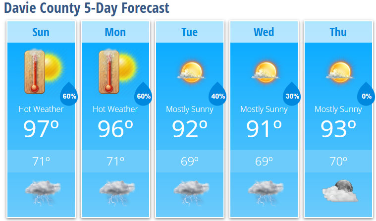
Today's Forecast
Expect another hot and humid afternoon with increasing clouds. High temperatures will reach 97°, while heat index values climb to around 103°.
Scattered showers and thunderstorms may begin developing after 2 PM, becoming more numerous after 4 PM. Some storms could produce damaging wind gusts, frequent lightning, torrential rainfall, and localized flooding.
- High: 97°
- Heat Index: Up to 103°
- Rain Chance: 60%
- Wind: Light and variable
Tonight
Any evening thunderstorms will gradually diminish with only a slight chance of lingering showers around midnight. Skies become partly cloudy overnight.
- Low: 71°
- Rain Chance: 30%
Monday
Another hot day is expected with highs reaching 96° and heat index values once again climbing to around 103°.
Most locations will stay dry through much of the afternoon before scattered showers and thunderstorms develop after 4 PM.
- High: 96°
- Heat Index: Up to 103°
- Rain Chance: 30% during the afternoon
Monday Night
Showers and thunderstorms become more likely during the evening before gradually ending around midnight.
- Low: 71°
- Rain Chance: 60%
Tuesday
Temperatures ease back slightly, but it will remain hot with highs near 92°. Afternoon and evening thunderstorms remain possible, and a few storms could become more organized than earlier in the week.
- High: 92°
- Rain Chance: 40%
Wednesday
A mix of sunshine and clouds with only isolated late-day thunderstorms.
- High: 91°
- Low: 69°
Thursday
Mostly sunny and hot.
- High: 93°
- Low: 70°
What I'm Watching
The weather pattern this week looks much more like a typical July. Hot afternoons and warm, humid nights will continue while scattered thunderstorms develop during the peak heating of the day.
Although storms will be scattered, any storm that forms could quickly become strong with damaging wind gusts, frequent lightning, and very heavy rainfall. Tuesday currently appears to offer the greatest potential for stronger storms as a weak cold front approaches the region.
Heat Safety
Even without a Heat Advisory, the combination of heat and humidity will make it feel well over 100 degrees during the afternoon.
- Drink plenty of water throughout the day.
- Take frequent breaks in the shade or air conditioning.
- Never leave children or pets in parked vehicles.
- If you have outdoor plans, keep a close eye on the sky and have multiple ways to receive weather warnings.
Overall, expect hot afternoons, muggy nights, and daily chances for afternoon and evening thunderstorms, with the best coverage through Tuesday before storm chances become a little more isolated later in the week.