Davidson County Forecast: Hot Sunday Gives Way to a More Active Weather Pattern
The hottest weather is beginning to ease across Davidson County, but summer heat isn't going away just yet. Sunday will still be another hot day with highs in the upper 90s before a more active weather pattern develops, bringing daily chances for showers and thunderstorms through much of the upcoming week.
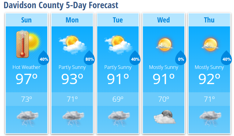
Sunday's high will reach 97°, with heat index values around 100°. While much of the day will remain dry, scattered showers and thunderstorms are expected to develop during the late afternoon and evening. A few storms could become strong, producing damaging wind gusts and heavy downpours.
Monday and Tuesday look to be the most active days of the week as a weakening ridge allows multiple disturbances and a cold front to move through the region. This will increase the coverage of showers and thunderstorms, with some storms capable of producing locally heavy rainfall and isolated damaging winds.
Day-by-Day Forecast
Sunday: Mostly sunny and hot with a high near 97°. Heat index values near 100°. A 30% chance of showers and thunderstorms after 5 PM.
Sunday Night: Partly cloudy with a 40% chance of showers and thunderstorms during the evening. Low near 73°.
Monday: Showers and thunderstorms become likely after 2 PM. High near 93°. 80% chance of rain.
Monday Night: Showers and thunderstorms likely through much of the evening. Low around 71°. 80% chance of rain.
Tuesday: Partly sunny with a high near 91°. A 40% chance of afternoon showers and thunderstorms.
Tuesday Night: Mostly cloudy with a 40% chance of showers and thunderstorms. Low near 69°.
Wednesday: Mostly sunny with a high near 91°.
Wednesday Night: Partly cloudy with a low around 70°.
Thursday: Mostly sunny with a high near 92°. A 40% chance of afternoon showers and thunderstorms.
What Has Changed?
- Sunday will be a little less hot than the holiday weekend, but heat remains a concern.
- Monday and Tuesday continue to be the wettest days of the upcoming week.
- A few storms Sunday through Tuesday could produce damaging wind gusts and locally heavy rainfall.
Davidson County Weather Summary
The dangerous holiday heat is beginning to ease, but another hot day is expected Sunday with highs near 97°. A more active summer weather pattern develops beginning Sunday afternoon, with daily chances for showers and thunderstorms continuing through much of next week. Monday and Tuesday currently offer the best opportunity for widespread rainfall, while temperatures settle into the lower 90s by midweek. Although it won't be as hot, humidity will remain high, keeping conditions feeling muggy.