Rowan County Forecast: Dangerous Heat Continues Through the Fourth of July Weekend
Published: Friday, July 3, 2026
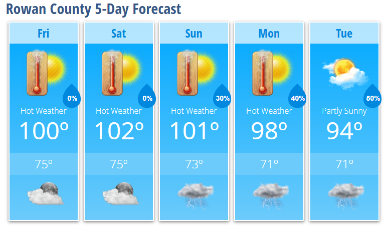
Dangerous heat remains the top weather story across Rowan County as temperatures continue climbing into the triple digits through the Independence Day weekend. Heat index values will exceed 100 degrees each afternoon, making outdoor activities potentially hazardous if proper precautions aren't taken.
While the holiday weekend will be dominated by sunshine and intense heat, rain chances remain very limited through Sunday before scattered afternoon and evening thunderstorms become more common early next week.
Today's Forecast (Friday)
Expect sunny skies and dangerous heat with a high near 100°. When humidity is factored in, it will feel as hot as 107° during the afternoon. Winds will remain light, becoming southeast around 5 mph later today.
Tonight will stay mostly clear and warm with a low around 75°.
Independence Day Forecast (Saturday)
The Fourth of July will be another extremely hot day. Expect mostly sunny skies with a high near 102°. Heat index values will reach around 105°, so anyone attending parades, cookouts, or fireworks should take frequent breaks in the shade or air conditioning and stay well hydrated.
Saturday night remains mostly clear with temperatures only falling to around 75°.
Sunday
Little change is expected as hot weather continues. High temperatures will reach around 101° under mostly sunny skies.
A 30% chance of showers and thunderstorms develops Sunday evening, mainly before midnight.
Looking Ahead
Heat gradually eases next week, but temperatures will remain well above normal.
- Monday: Mostly sunny and hot with a high near 98°. A 30% chance of afternoon thunderstorms.
- Tuesday: Partly sunny with a high near 94°. A 50% chance of afternoon and evening showers and thunderstorms.
Forecast Highlights
- Dangerous heat continues through the Independence Day weekend.
- Afternoon heat index values between 105° and 107° will create dangerous conditions.
- The holiday weekend looks mostly dry for outdoor celebrations.
- Scattered afternoon and evening thunderstorms return beginning Sunday night and become more common Monday and Tuesday.
- Any storm that develops next week could produce locally damaging wind gusts.
Heat Safety
If you have outdoor plans this holiday weekend:
- Drink plenty of water before you become thirsty.
- Take frequent breaks in air-conditioned buildings or shaded areas.
- Wear lightweight, light-colored clothing.
- Never leave children or pets inside a parked vehicle, even for a short time.
- Check on elderly neighbors and anyone without reliable air conditioning.
The prolonged stretch of dangerous heat can place additional stress on the body, even for healthy individuals. Plan outdoor activities during the early morning or late evening whenever possible.
Rowan County Weather Summary
The forecast remains on track with dangerous heat as the primary concern through Sunday. While scattered thunderstorms return early next week, they will offer only localized relief from the heat. Until then, expect a classic midsummer holiday weekend featuring plenty of sunshine, temperatures near or above 100 degrees, and dangerous afternoon heat indices.