Davidson County Forecast: Dangerous Heat Peaks Through the Holiday Weekend, Storm Chances Return Next Week
Published: Friday Evening, July 3, 2026
Dangerous heat remains the primary weather concern across Davidson County as the Fourth of July holiday weekend continues. Temperatures will climb into the triple digits on Independence Day, and the prolonged stretch of hot days and warm nights will continue to increase the risk of heat-related illnesses.
While the holiday weekend will remain mostly dry, a more typical summertime weather pattern returns early next week with increasing chances for afternoon and evening thunderstorms.
Independence Day Forecast
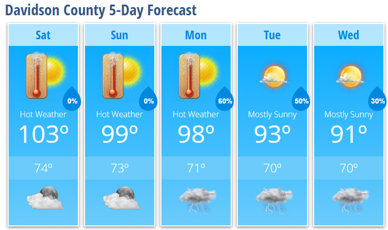
Saturday will be the hottest day of the holiday weekend with mostly sunny skies and a high near 103°.
Even though the forecast remains largely dry, the combination of triple-digit temperatures and several consecutive days of intense heat will create dangerous conditions for anyone attending parades, cookouts, sporting events, or fireworks displays.
Saturday night stays mostly clear and warm with a low around 74°.
Sunday
Sunday remains hot with mostly sunny skies and a high near 99°.
Most locations are expected to stay dry through the day and overnight, although an isolated shower or thunderstorm cannot be completely ruled out. Most outdoor activities should remain unaffected.
Looking Ahead
Rain and thunderstorm chances increase as we head into the new work week while temperatures slowly begin trending downward.
- Monday: Mostly sunny and hot with a high near 98°. Showers and thunderstorms become likely after 2 PM with a 60% chance of rain.
- Tuesday: Mostly sunny with a high near 93°. A 50% chance of afternoon and evening showers and thunderstorms.
- Wednesday: Mostly sunny with a high near 91°. A 30% chance of afternoon and evening thunderstorms.
While widespread severe weather is not expected, a few storms could produce isolated damaging wind gusts and locally heavy rainfall.
Forecast Highlights
- Dangerous heat continues through the holiday weekend.
- High temperatures peak near 103° on Independence Day.
- Most Fourth of July celebrations should remain dry.
- Several consecutive days of extreme heat continue to increase heat-related health risks.
- Thunderstorm chances increase Monday and continue through the middle of next week.
- A few storms next week may produce damaging wind gusts and heavy downpours.
Heat Safety
If you'll be celebrating outdoors this holiday weekend:
- Drink plenty of water throughout the day.
- Take frequent breaks in the shade or air conditioning.
- Wear lightweight, light-colored clothing.
- Limit strenuous activity during the hottest part of the afternoon.
- Never leave children or pets inside a parked vehicle.
- Check on elderly relatives, neighbors, and anyone without reliable air conditioning.
Warm overnight temperatures in the 70s will provide little relief, allowing heat stress to build with each passing day.
Davidson County Weather Summary
The Fourth of July weekend looks favorable for outdoor celebrations, with plenty of sunshine and only a very small chance of an isolated shower. Dangerous heat remains the biggest concern, especially on Saturday when highs reach around 103°. Beginning Monday, scattered afternoon and evening thunderstorms return while temperatures gradually settle back into the lower 90s by the middle of next week.