Davie County Forecast: Dangerous Heat Continues Through the Holiday Weekend
Dangerous summer heat will continue across Davie County through the Fourth of July holiday weekend before a more typical summertime weather pattern returns early next week.
Afternoon temperatures will climb into the upper 90s and near 100 degrees through Saturday, with heat index values reaching 102 to 103 degrees during the hottest part of the day. While Heat Advisories are not currently anticipated, several consecutive days of intense heat will still pose a risk for heat-related illnesses.
The good news is that a pattern change arrives late this weekend, bringing increased chances for afternoon and evening thunderstorms along with temperatures that are closer to normal for early July.
Forecast
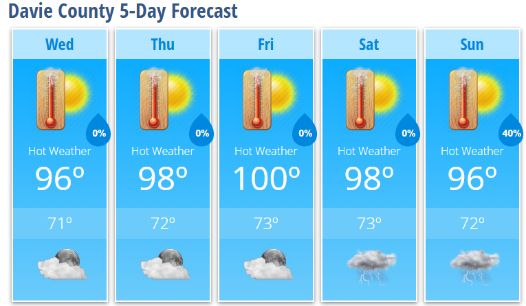
Wednesday
Sunny and hot with a high near 96°. Heat index values as high as 102°.
Wednesday Night
Mostly clear with a low around 71°.
Thursday
Sunny and hot with a high near 98°. Heat index values as high as 103°.
Thursday Night
Mostly clear with a low around 73°.
Friday
Sunny and hot with a high near 100°.
Friday Night
Mostly clear with a low around 74°.
Independence Day (Saturday)
Sunny and hot with a high near 98°.
Saturday Night
Partly cloudy with a low around 74°.
Sunday
A 40% chance of showers and thunderstorms after 2 PM. Mostly sunny and hot with a high near 96°.
Sunday Night
A 40% chance of showers and thunderstorms. Mostly cloudy with a low around 72°.
Dangerous Heat Through Saturday
A strong ridge of high pressure will remain over the southern Appalachians through the holiday weekend, producing one of the hottest stretches of weather so far this summer.
Afternoon highs will climb into the upper 90s and around 100 degrees, while heat index values will reach 102 to 103 degrees. Although humidity will decrease somewhat during the afternoon, the combination of hot temperatures and several consecutive days of heat will still create hazardous conditions for anyone spending extended time outdoors.
If you'll be celebrating Independence Day outside, remember to:
- Drink plenty of water throughout the day.
- Take frequent breaks in the shade or air conditioning.
- Wear lightweight, light-colored clothing.
- Never leave children or pets inside a parked vehicle.
- Check on elderly neighbors, friends, and family members.
More Typical Summer Weather Returns
Confidence continues to increase that the weather pattern will shift beginning Sunday.
As the upper-level ridge weakens and moves offshore, afternoon temperatures will ease back into the lower to middle 90s while daily shower and thunderstorm chances return.
Scattered thunderstorms are expected to become more common Sunday and into early next week. Some stronger storms could produce gusty winds and small hail, which is typical during the summer months.
Looking Ahead
The Fourth of July forecast remains hot and dry across Davie County, making for favorable weather for outdoor celebrations and fireworks. Just be sure to take precautions if you'll be outside during the afternoon heat.
Beginning Sunday, keep an eye on the sky as scattered afternoon and evening thunderstorms make their return, along with slightly cooler temperatures.