Davie County Forecast: Dangerous Heat Builds Through the Fourth of July Weekend
Dangerous summer heat is set to take hold across Davie County through the remainder of the week and into the Independence Day holiday weekend. Afternoon temperatures will climb into the upper 90s and near 100 degrees, while heat index values will regularly exceed 100 degrees.
Although no Heat Advisories have been issued at this time, several consecutive days of intense heat can still be dangerous, especially for those spending extended periods outdoors during holiday celebrations.
Forecast
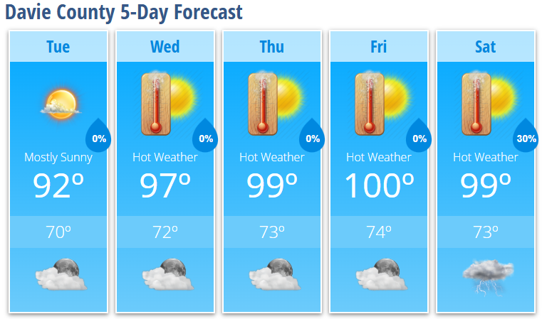
Tuesday
Mostly sunny with a high near 92°. Light east wind.
Tuesday Night
Mostly clear with a low around 70°.
Wednesday
Sunny and hot with a high near 97°. Heat index values as high as 102°.
Wednesday Night
Mostly clear with a low around 72°.
Thursday
Sunny and very hot with a high near 99°.
Thursday Night
Mostly clear with a low around 73°.
Friday
Sunny and dangerously hot with a high near 100°.
Friday Night
Mostly clear with a low around 74°.
Independence Day (Saturday)
Sunny and hot with a high near 99°.
Saturday Night
A 30% chance of showers and thunderstorms between 8:00 PM and 2:00 AM. Partly cloudy with a low around 73°.
Heat Becomes the Main Weather Story
A strong area of high pressure will strengthen over the Southeast through the week, bringing one of the hottest stretches of weather so far this summer. High temperatures will rise into the upper 90s by Wednesday and Thursday before reaching around 100 degrees Friday.
Despite somewhat lower afternoon humidity, heat index values are still expected to exceed 100 degrees. Several consecutive days of extreme heat can increase the risk of heat-related illnesses, particularly for anyone working or enjoying outdoor activities during the holiday.
If you'll be outside this week:
- Drink plenty of water throughout the day.
- Take frequent breaks in the shade or air conditioning.
- Wear lightweight, light-colored clothing.
- Check on elderly family members and neighbors.
- Never leave children or pets inside parked vehicles.
Dry Pattern Continues
Most shower and thunderstorm activity will remain confined to the North Carolina mountains through the week. Davie County is expected to stay dry through Saturday, with only a slight chance of showers or thunderstorms developing Saturday evening and overnight as the weather pattern begins to shift.
Rain chances are expected to increase late in the holiday weekend and into early next week.
Near-Record Heat Possible
Afternoon temperatures this week will approach daily record highs across the region. While Davie County may fall just short of those records, highs in the upper 90s to around 100° will make for one of the hottest periods of the summer.
Whether you're grilling, heading to the lake, watching fireworks, or spending time with family, make plans now to stay cool and hydrated during this prolonged stretch of dangerous heat.