Rowan County Forecast: Heat Builds Through the Week with Highs Near 100° by the Fourth of July
Summer is about to turn up the heat across Rowan County. While temperatures will be close to normal on Monday, a strengthening area of high pressure will bring a prolonged stretch of hot, mainly dry weather through the remainder of the week. By Wednesday through Friday, afternoon highs will be pushing the upper 90s, with heat index values climbing above 100 degrees in many locations.
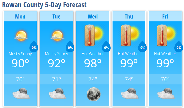
Monday
Clouds will gradually increase through the day with a high near 90°. Winds will remain light out of the northeast at 3 to 6 mph. Monday night will be partly cloudy with a low around 70°.
Tuesday
Expect mostly sunny skies and another warm summer day with a high near 92°. Tuesday night will be mostly clear with a low around 71°.
Wednesday
The heat really begins to intensify. Sunny skies and a strengthening upper-level ridge will push temperatures to around 98°. Wednesday night will remain warm and clear with a low near 74°.
Thursday
Another very hot day is expected with abundant sunshine and a high near 99°. Overnight temperatures will only fall to around 74°, providing little relief from the heat.
Friday
Little change is expected as sunshine continues and highs once again approach 99°. Friday night will be mostly clear with a warm low around 76°.
What Has Changed?
The forecast continues to trend hotter through the second half of the week as a strong dome of high pressure settles over the Tennessee Valley and Appalachians. Rain chances become very limited after Monday, allowing temperatures to climb each afternoon.
Heat Becomes the Main Story
Heat will be the biggest weather concern this week. Afternoon heat index values are expected to exceed 100 degrees across Rowan County by mid to late week, especially Wednesday through Friday. While the exact heat index depends on humidity levels, confidence is high that this will be one of the hottest stretches of weather so far this summer.
If you'll be spending time outdoors, especially with Fourth of July activities approaching, remember to:
- Drink plenty of water.
- Wear lightweight, light-colored clothing.
- Take frequent breaks in the shade or air conditioning.
- Never leave children or pets unattended in a vehicle, even for a few minutes.
Looking Ahead to the Holiday Weekend
Current indications suggest the hot pattern will continue into the Independence Day weekend. While isolated afternoon thunderstorms cannot be ruled out, widespread rainfall is not expected, and many locations could remain dry through much of the holiday period.
I'll continue to monitor the forecast throughout the week, especially as we approach the Fourth of July, and will provide updates if any Heat Advisories become necessary.