Storm Chances Continue Sunday Before Dangerous Heat Builds Across Davie County Next Week
After thunderstorms moved through Davie County on Saturday, I'll continue watching for another round of showers and thunderstorms on Sunday before a much hotter weather pattern settles into the area next week.
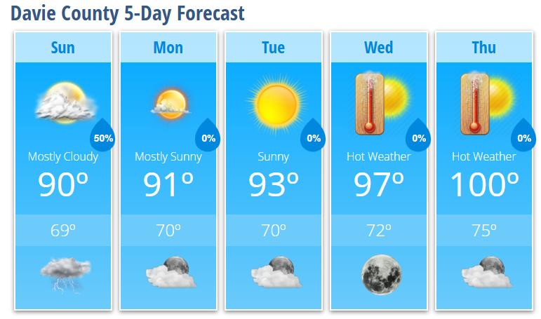
Sunday will feature mostly cloudy skies with a 50% chance of showers and thunderstorms, mainly after 5:00 PM. While much of the day will be dry, a few showers or storms could develop earlier if weakening storms move in from the northwest during the morning.
The severe weather threat appears lower than what we experienced Saturday, but I can't completely rule out isolated strong wind gusts if enough sunshine develops to destabilize the atmosphere during the afternoon.
High temperatures will reach around 90 degrees, with muggy conditions making it feel even warmer.
Any showers and thunderstorms will gradually diminish Sunday evening, with skies becoming mostly clear overnight and temperatures falling to around 69 degrees.
Beginning Monday, attention shifts from storms to the heat.
A strengthening area of high pressure will build across the eastern United States, sending temperatures steadily higher throughout the week. Highs will reach 91 degrees Monday, 93 degrees Tuesday, 97 degrees Wednesday, and 100 degrees by Thursday.
Heat index values are expected to climb above 100 degrees by the middle of the week, with the hottest conditions likely arriving Thursday and continuing into the Independence Day holiday weekend. If current trends continue, heat headlines may eventually be needed later this week.
Storm chances also become much lower after Monday as the ridge strengthens, with most afternoon thunderstorms expected to remain over the mountains.
Davie County Forecast
Sunday
- Mostly cloudy.
- High: 90°
- 50% chance of showers and thunderstorms, mainly after 5 PM.
Sunday Night
- 30% chance of evening thunderstorms.
- Becoming mostly clear overnight.
- Low: 69°
Monday
- Mostly sunny.
- High: 91°
Tuesday
- Sunny.
- High: 93°
Wednesday
- Sunny and hot.
- High: 97°
Thursday
- Sunny and very hot.
- High: 100°
What I'm Watching
- Sunday: Another round of scattered showers and thunderstorms is possible, especially late in the day. While widespread severe weather is not expected, a few storms could produce gusty winds.
- Mid to Late Week: Heat continues to build with highs climbing into the upper 90s to around 100 degrees. Heat index values above 100 degrees are expected, with the greatest potential for dangerous heat arriving Thursday and lasting into the Independence Day holiday weekend.
- Rain Chances: After Monday, rain chances become much lower as high pressure strengthens across the Southeast.
I'll continue monitoring Sunday's storm potential along with the increasingly dangerous heat expected later this week and will provide updates as forecast confidence continues to increase.