Rowan County Forecast: Storm Chances Continue This Weekend, Heat Builds Through Midweek
Good afternoon! Here's my latest forecast for Rowan County.
The weather pattern over the next several days will feature a familiar summertime combination of hot afternoons and isolated thunderstorms. While not everyone will see rain this weekend, a few afternoon and evening storms remain possible before the bigger story shifts to building heat next week.
Saturday
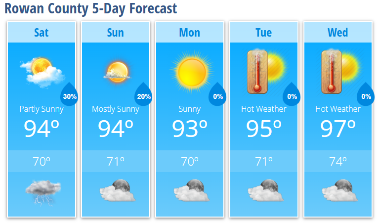
Saturday starts with a mix of sun and clouds before becoming mostly sunny by late morning. High temperatures climb to around 94 degrees.
There is a 30% chance of showers and thunderstorms after 4 PM. Most neighborhoods will stay dry, but any storm that develops could produce gusty winds, frequent lightning, and brief heavy rainfall. Widespread severe weather is not expected, although an isolated storm could become strong.
Saturday night brings a 30% chance of lingering showers and thunderstorms before 9 PM, followed by clearing skies and a low around 70 degrees.
Sunday
Sunday will be another hot summer day with mostly sunny skies and highs reaching 94 degrees. While the majority of the day looks dry, I can't completely rule out an isolated shower or thunderstorm during the late afternoon or evening.
Early Next Week
Monday remains sunny with a high near 93 degrees before the heat continues to build.
By Tuesday and Wednesday, temperatures climb into the middle to upper 90s, and this is when heat becomes the primary weather story. Forecast guidance continues to indicate that heat index values could reach or exceed 100 degrees by the middle of the week, with several days of dangerous heat possible as we approach the July 4th holiday.
If you're planning to spend time outdoors next week, begin preparing now by staying hydrated, taking frequent breaks, and limiting strenuous outdoor activity during the hottest part of the afternoon.
My Forecast Highlights
- Isolated afternoon and evening thunderstorms remain possible through the weekend.
- Any storm that develops could produce gusty winds, lightning, and brief heavy rainfall.
- High temperatures remain in the mid 90s through the weekend.
- Heat becomes the biggest weather story next week, with heat index values potentially exceeding 100° by midweek.
- I'm also watching what could become an extended stretch of dangerous heat leading into the July 4th holiday.
Rowan County Forecast
Saturday: Partly sunny early, then sunny. High 94°. 30% chance of afternoon thunderstorms.
Saturday Night: Mostly cloudy early, then becoming mostly clear. Low 70°. 30% chance of evening thunderstorms.
Sunday: Mostly sunny. High 94°.
Sunday Night: Partly cloudy. Low 71°. 20% chance of an evening thunderstorm.
Monday: Sunny. High 93°.
Monday Night: Mostly clear. Low 70°.
Tuesday: Sunny and hot. High 95°.
Tuesday Night: Mostly clear. Low 71°.
Wednesday: Sunny and hot. High 97°.
Wednesday Night: Mostly clear. Low 74°.