Davidson County Forecast: Weekend Storm Chances Return, Dangerous Heat Looms Next Week
Good Friday morning! Here's my latest forecast for Davidson County.
After several quieter afternoons, we're transitioning back into a more active summertime pattern. Scattered thunderstorms return today and remain possible through the weekend, with Saturday bringing the greatest opportunity for a few strong to severe storms. Beyond the weekend, attention quickly shifts to what could become an extended period of dangerous heat.
Today
Expect mostly sunny skies this morning before clouds begin to increase this afternoon. High temperatures will climb to around 89 degrees. There is a 30% chance of showers and thunderstorms after 3 PM, and while many locations will stay dry, any storm that develops could produce heavy rain, gusty winds, and frequent lightning.
Tonight, a few showers and thunderstorms remain possible before 8 PM before skies become partly cloudy. Overnight lows will settle around 70 degrees.
Saturday
Saturday will likely be the most active day of the weekend with a 40% chance of afternoon and evening thunderstorms. Highs reach around 92 degrees.
The atmosphere will become increasingly unstable during the afternoon, allowing a few storms to become strong or severe. Damaging straight-line winds will be the primary concern, although torrential rainfall and dangerous lightning will also accompany the stronger storms.
If you have outdoor plans Saturday afternoon or evening, be sure to have a way to receive weather alerts.
Sunday
Sunday turns hotter with highs climbing to around 93 degrees. Only isolated afternoon thunderstorms are expected, but I'll continue monitoring for any storm complexes that may develop upstream and move into the area.
Early Next Week
The biggest weather story quickly becomes the heat.
Monday and Tuesday remain sunny with highs in the lower 90s, but conditions become increasingly hot by the middle of next week. Current trends suggest a potentially dangerous and extended heat wave beginning around Wednesday, July 1, and lasting through the Independence Day weekend.
High temperatures could approach or exceed 100 degrees in some areas, while heat index values may climb above 105 degrees. Overnight temperatures may remain unusually warm, offering little relief after sunset.
While forecast details will continue to be refined over the coming days, now is the time to begin thinking about ways to stay cool if these projections continue.
My Forecast Highlights
- Afternoon and evening thunderstorms return today and continue through the weekend.
- Saturday has the greatest chance for strong to severe thunderstorms with damaging wind gusts possible.
- Temperatures climb into the 90s through early next week before a potentially dangerous heat wave develops by midweek.
- Heat index values could exceed 105° later next week if current trends continue.
- I'll continue monitoring both this weekend's storm potential and next week's developing heat and provide updates as confidence increases.
Davidson County Forecast
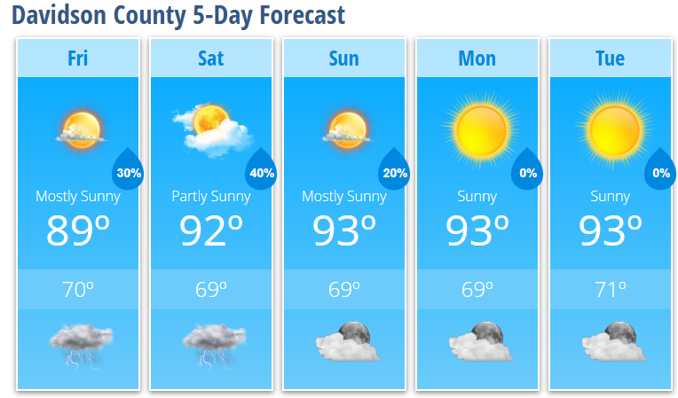
Friday: Mostly sunny. High 89°. 30% chance of afternoon thunderstorms.
Friday Night: Partly cloudy. Low 70°. 30% chance of evening storms.
Saturday: Partly sunny. High 92°. 40% chance of afternoon thunderstorms.
Saturday Night: Partly cloudy. Low 69°. 30% chance of early evening storms.
Sunday: Mostly sunny. High 93°. 20% chance of afternoon thunderstorms.
Sunday Night: Partly cloudy. Low 69°.
Monday: Sunny. High 93°.
Monday Night: Mostly clear. Low 69°.
Tuesday: Sunny. High 93°.
Tuesday Night: Mostly clear. Low 71°.