Rowan County Forecast: Heat Builds Through the Weekend, Storm Chances Return
After a quiet and pleasant stretch of weather, summer is about to remind us it's here. Sunshine dominates today before scattered afternoon thunderstorms make a return Friday and continue through the weekend. While rain chances remain relatively low each day, temperatures will continue climbing into the middle 90s, with humidity pushing heat index values into the triple digits.
Forecast at a Glance
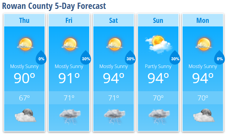
Today
Mostly sunny with a high near 90°. Winds remain light before turning south-southwest around 5 mph this afternoon.
Tonight
Mostly clear and comfortable with a low around 67°.
Friday
A mix of sun and clouds with a 30% chance of afternoon thunderstorms. High near 91°.
Friday Night
A few evening thunderstorms remain possible before skies become partly cloudy overnight. Low around 71°.
Saturday
Mostly sunny and hotter with a high near 94°. A 30% chance of late afternoon and evening thunderstorms.
Saturday Night
Partly to mostly cloudy with a lingering chance of an evening thunderstorm. Low around 71°.
Sunday
Partly sunny, hot and humid with a high near 94°. Another 30% chance of an afternoon thunderstorm.
Sunday Night
Partly cloudy with a slight chance of an early evening storm. Low around 70°.
Monday
Mostly sunny and continued hot with a high near 94°.
Monday Night
Mostly clear with a low around 70°.
What I'm Watching
High pressure remains in control today, keeping Rowan County dry. Beginning Friday, moisture flowing in from the Atlantic around the Bermuda High will allow isolated to scattered afternoon and evening thunderstorms to develop each day through the weekend. Coverage should remain limited, so many neighborhoods may stay completely dry while others briefly see heavy rain and lightning.
The more significant weather story will become the heat.
Afternoon temperatures in the middle 90s combined with increasing humidity will likely push heat index values between 100° and 103° this weekend. Looking ahead into the middle of next week, confidence continues to increase that heat indices could climb even higher, with some locations potentially approaching 105°, which is the threshold for Heat Advisory conditions.
If you're spending time outdoors this weekend or next week, drink plenty of water, wear lightweight clothing, take frequent breaks in the shade or air conditioning, and never leave children or pets inside parked vehicles.
My Bottom Line
This is a classic summertime forecast. Most of us will stay dry each day, but keep an eye on the sky during the afternoon and evening hours for a pop-up thunderstorm. The bigger headline will be the steadily increasing heat, so plan ahead if you have outdoor activities scheduled this weekend or early next week.