Davie County Forecast: Summer Heat Intensifies Through the Weekend
Summer is about to turn up the heat across Davie County. We'll stay dry today with plenty of sunshine, but beginning Friday, isolated afternoon and evening thunderstorms return to the forecast. While not everyone will see rain, nearly everyone will notice the increasing heat and humidity as temperatures climb into the lower to middle 90s through early next week.
Forecast at a Glance
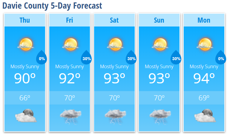
Today
Mostly sunny with a high near 90°. Light winds become south-southwest around 5 mph this afternoon.
Tonight
Mostly clear with a pleasant overnight low around 66°.
Friday
Mostly sunny with a 30% chance of afternoon thunderstorms. High near 92°.
Friday Night
A few evening thunderstorms remain possible before skies gradually become partly cloudy. Low around 70°.
Saturday
Mostly sunny and hot with a high near 93°. A 30% chance of late afternoon and evening thunderstorms.
Saturday Night
Partly cloudy with a lingering chance of an evening thunderstorm. Low around 70°.
Sunday
Mostly sunny, hot and humid with a high near 93°. Another 30% chance of an afternoon thunderstorm.
Sunday Night
Partly cloudy with a slight chance of an early evening thunderstorm. Low around 70°.
Monday
Mostly sunny and continued hot with a high near 94°.
Monday Night
Mostly clear with a low around 69°.
What I'm Watching
High pressure remains in control today, keeping conditions quiet across Davie County. Beginning Friday, the Bermuda High strengthens over the Atlantic, allowing more moisture to move into the Carolinas. That will bring daily opportunities for scattered afternoon and evening thunderstorms through the weekend.
These storms should remain isolated to scattered in nature, so many locations will stay dry while others experience brief heavy rain, gusty winds, and lightning. At this time, widespread severe weather is not expected.
The bigger weather story continues to be the heat.
Afternoon temperatures will climb into the lower and middle 90s through the weekend while humidity steadily increases. That combination will likely push heat index values into the 100° to 103° range during the afternoon hours.
Looking into the middle of next week, confidence is growing that the hottest stretch of weather so far this year will develop. Heat index values could approach 105° if current trends continue, especially across the Piedmont.
My Bottom Line
The forecast is becoming increasingly summer-like. Expect plenty of sunshine each morning, isolated afternoon thunderstorms, and steadily increasing heat through the weekend. If you have outdoor plans, schedule strenuous activities during the morning whenever possible, stay hydrated, and take frequent breaks in the shade or air conditioning as the hottest part of the day arrives.