Davidson County Forecast: Weekend Storm Chances Increase as Heat Builds
Summer weather is settling into Davidson County with hotter temperatures and increasing afternoon thunderstorm chances through the weekend. While not everyone will see rain, Saturday currently stands out as the day with the greatest potential for both widespread storms and a few isolated severe thunderstorms.
Beyond the weekend, attention shifts to a prolonged stretch of heat that could become dangerous by the middle and latter part of next week.
Forecast at a Glance
Friday
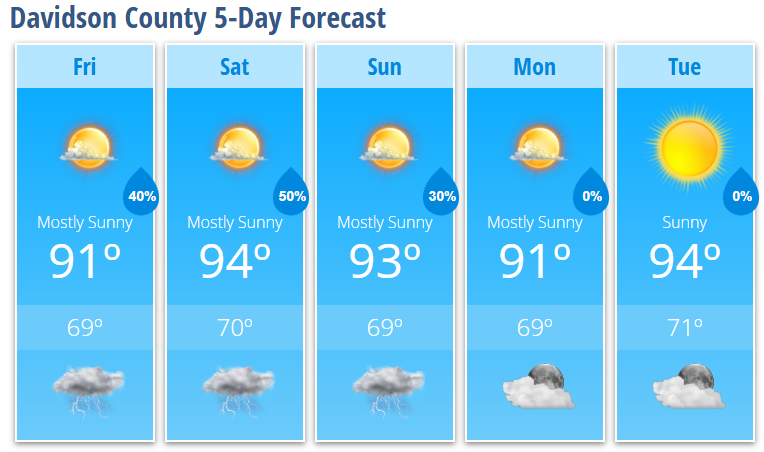
Increasing clouds with a 30% chance of afternoon and evening showers and thunderstorms after 4 PM. High near 91°.
Friday Night
Partly cloudy with a low around 69°.
Saturday
Partly sunny with a high near 94°. A 50% chance of afternoon and evening thunderstorms.
Saturday Night
Partly cloudy with a 30% chance of evening thunderstorms. Low around 70°.
Sunday
Mostly sunny with a high near 93°. A 30% chance of afternoon thunderstorms.
Sunday Night
Partly cloudy with a 30% chance of an early evening thunderstorm. Low around 69°.
Monday
Mostly sunny with a high near 91°.
Monday Night
Mostly clear with a low around 69°.
Tuesday
Sunny and hot with a high near 94°.
Tuesday Night
Mostly clear with a low around 71°.
What I'm Watching
Thunderstorm chances begin increasing Friday afternoon as additional moisture moves into central North Carolina. A weak upper-level disturbance may provide enough lift for scattered showers and thunderstorms to develop during the late afternoon and evening.
Saturday is the day I'll be watching most closely.
A cold front approaching from the north, combined with hot temperatures and increasing humidity, will create a more favorable environment for thunderstorms. The Storm Prediction Center has placed Davidson County under a Marginal Risk (Level 1 of 5) for severe weather on Saturday. While widespread severe weather is not expected, a few storms could produce damaging wind gusts, especially during the afternoon and evening hours.
Storm chances continue into Sunday before gradually decreasing early next week as strong high pressure begins taking control.
The bigger weather story beyond the weekend will be the heat.
Temperatures ease slightly Monday before climbing again by midweek as a strong ridge of high pressure expands across the Southeast. Forecast guidance continues to suggest portions of the Piedmont could approach 100° later next week, while heat index values climb well into the triple digits. If current trends continue, Heat Advisories may become necessary.
My Bottom Line
Prepare for a hot and increasingly humid weekend with scattered afternoon and evening thunderstorms. Saturday currently carries the greatest chance for storms, and a few could become strong with damaging wind gusts.
Looking farther ahead, I'm closely monitoring the potential for dangerous heat during the middle and latter part of next week. I'll continue updating the forecast as confidence increases regarding both the heat and any severe weather potential.