Davidson County Forecast: Hotter Days Ahead as Storm Chances Return
The quiet weather continues today, but we'll begin transitioning back to a more typical summertime pattern as we head into the weekend. That means afternoon and evening thunderstorm chances gradually increase while temperatures climb into the lower and middle 90s. Although forecast highs have been trimmed slightly compared to previous forecasts, the combination of heat and humidity will still make it feel much hotter.
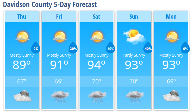
Forecast at a Glance
Today
Mostly sunny with a high near 89°. Light south winds develop this afternoon.
Tonight
Mostly clear with a low around 67°.
Friday
Mostly sunny with just a 20% chance of an afternoon thunderstorm. High near 91°.
Friday Night
A 30% chance of evening showers and thunderstorms before skies become partly cloudy. Low around 69°.
Saturday
Mostly sunny and hotter with a high near 94°. A 30% chance of afternoon and evening thunderstorms.
Saturday Night
Partly to mostly cloudy with a 40% chance of evening thunderstorms. Low around 70°.
Sunday
Partly sunny with a high near 93°. A 40% chance of afternoon and evening thunderstorms.
Sunday Night
A lingering 30% chance of evening thunderstorms before becoming partly cloudy. Low around 70°.
Monday
Mostly sunny with a high near 93°.
Monday Night
Mostly clear with a low around 69°.
What I'm Watching
Today remains dry thanks to weak high pressure across the region. Beginning Friday, a weak upper-level disturbance will move across the Carolinas while deeper moisture returns. That will allow isolated to scattered afternoon and evening thunderstorms to develop each day through the weekend.
Storm coverage should gradually increase by Sunday as a backdoor cold front approaches from the north. While widespread severe weather is not expected, a few stronger storms Sunday could produce gusty winds due to the hot, deeply mixed atmosphere.
The other story is the heat.
Temperatures climb into the lower and middle 90s this weekend while humidity steadily increases. Even though forecast highs have been lowered slightly, it will still feel significantly hotter during the afternoon, with heat index values approaching or exceeding 100° in many locations.
Early next week, a brief moderation in temperatures is possible before another stronger ridge builds eastward. That pattern could bring the hottest weather of the season during the middle to latter part of next week, with heat index values potentially approaching 105°.
My Bottom Line
Expect a classic summer weather pattern across Davidson County. Most mornings will be dry with plenty of sunshine before isolated afternoon and evening thunderstorms develop. The bigger concern will be the steadily increasing heat and humidity, so if you'll be spending time outdoors this weekend, stay hydrated, wear lightweight clothing, and take frequent breaks during the hottest part of the day.