Rowan County Forecast: Heat Builds Through the Weekend with Triple-Digit Heat Index Possible
The warming trend continues across Rowan County as temperatures climb well into the 90s over the next several days. While only isolated afternoon thunderstorms are expected through the weekend, the bigger story will be the increasing heat and humidity.
Hotter Days Ahead
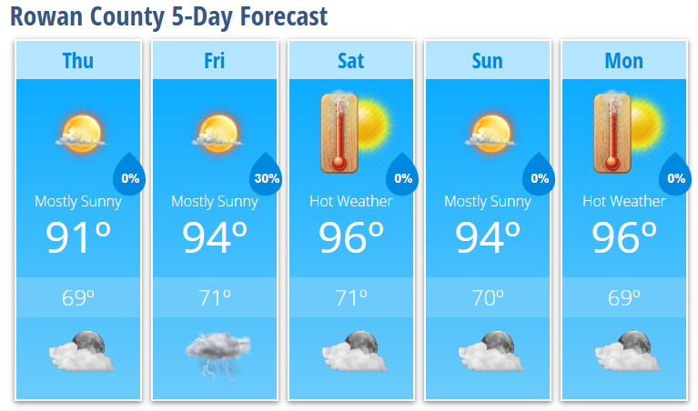
Thursday will feature mostly sunny skies with a high near 91 degrees. It will be another dry day as high pressure remains firmly in control across the Southeast.
Temperatures continue climbing Friday with highs reaching around 94 degrees. Most of the day will remain dry, although a 20 percent chance of an afternoon thunderstorm develops after 3 PM. Any storms that form will be isolated and brief.
Weekend Heat Intensifies
Saturday looks to be one of the hottest days so far this summer with mostly sunny skies and a high near 96 degrees.
Sunday remains very hot as well, with highs reaching the mid-90s under mostly sunny skies. While an isolated afternoon shower or thunderstorm cannot be ruled out, most locations should stay dry.
As humidity continues to increase, heat index values will likely climb into the 100 to 103-degree range across Rowan County during the afternoon hours this weekend. Confidence is also increasing that triple-digit heat indices could continue into the first half of next week.
Heat Safety Becomes Increasingly Important
This level of heat can affect anyone without adequate cooling or hydration.
If you'll be spending time outdoors this weekend:
- Drink plenty of water, even if you don't feel thirsty.
- Wear lightweight, light-colored clothing.
- Take frequent breaks in the shade or air conditioning.
- Avoid strenuous outdoor activity during the hottest part of the afternoon.
- Never leave children or pets inside a parked vehicle.
The safest times for outdoor activities will generally be before 11 AM or after 7 PM.
Looking Ahead
Monday continues the hot pattern with sunny skies and a high near 96 degrees. Current forecast trends suggest triple-digit heat index values may persist through the middle of next week as a strengthening upper-level ridge expands eastward.
While isolated afternoon thunderstorms remain possible from time to time, widespread rainfall is not expected, meaning the heat will remain the dominant weather story.
Rowan County Forecast
Thursday: Mostly sunny, high 91.
Thursday Night: Mostly clear, low 69.
Friday: Mostly sunny with a 20% chance of afternoon thunderstorms, high 94.
Friday Night: 30% chance of showers and thunderstorms, low 71.
Saturday: Mostly sunny and hot, high 96.
Saturday Night: Partly cloudy, low 71.
Sunday: Mostly sunny, high 94.
Sunday Night: Partly cloudy, low 70.
Monday: Sunny and hot, high 96.
Monday Night: Mostly clear, low 69.
The bottom line: The weather pattern is shifting toward prolonged summer heat. Afternoon heat index values of 100 to 103 degrees are becoming increasingly likely this weekend and could continue into next week. Stay hydrated, limit strenuous outdoor activity during the afternoon, and continue checking back for updates as I monitor the potential for any heat-related advisories.