Rowan County Forecast: Comfortable Today, Building Heat Through the Weekend
After several days of unsettled weather and thunderstorms, Rowan County gets a brief break today with lower humidity, sunshine, and temperatures a few degrees below normal. Enjoy it while you can, because a summer heat surge is on the way.
Today's Forecast
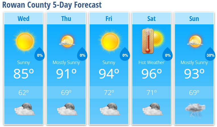
Sunny skies will dominate today with a high near 85 degrees. A light north wind and noticeably drier air will make it feel much more comfortable than what we've experienced recently.
Tonight will be partly cloudy with a low around 62 degrees and calm winds. It should be a pleasant night for any outdoor plans.
Heat Returns Thursday Through Saturday
Temperatures begin a steady climb on Thursday with mostly sunny skies and a high near 91 degrees. South-southwest winds will return during the afternoon, helping warmer and more humid air move back into the Carolinas.
Friday will be even hotter with sunny skies and a high around 94 degrees.
The hottest day of the forecast period appears to be Saturday when highs reach the mid-90s, with Rowan County expected to top out near 96 degrees. Combined with increasing humidity, heat index values could approach or exceed 100 degrees during the afternoon.
I'm watching the potential for Heat Advisory criteria this weekend. Whether that happens will depend on exactly how much humidity remains in place during the afternoon hours.
Storm Chances Return Sunday
Most of the weekend looks dry, but isolated afternoon and evening thunderstorms return Sunday as moisture continues to increase across the region.
Sunday will feature mostly sunny skies and another hot day with highs around 93 degrees. A 30 percent chance of showers and thunderstorms develops after 2 PM, with a few storms lingering into the evening before diminishing.
Looking Ahead
The latest forecast guidance continues to suggest temperatures may ease slightly on Monday before another warming trend develops by the middle of next week.
Rowan County Forecast
Wednesday: Sunny, high 85.
Wednesday Night: Partly cloudy, low 62.
Thursday: Mostly sunny, high 91.
Thursday Night: Mostly clear, low 69.
Friday: Sunny, high 94.
Friday Night: Partly cloudy, low 72.
Saturday: Mostly sunny and hot, high 96.
Saturday Night: Partly cloudy, low 71.
Sunday: 30% chance of afternoon thunderstorms, high 93.
Sunday Night: 30% chance of evening thunderstorms, low 69.
The bottom line: Enjoy today's comfortable conditions because summer heat is about to take center stage. The hottest weather of the season so far arrives Friday and Saturday, with heat index values potentially climbing above 100 degrees before scattered storm chances return later in the weekend.