Davidson County Forecast: Pleasant Today, Hotter Weekend Ahead
A refreshing break from the recent heat continues across Davidson County today, but summer temperatures are poised to make a strong comeback heading into the weekend.
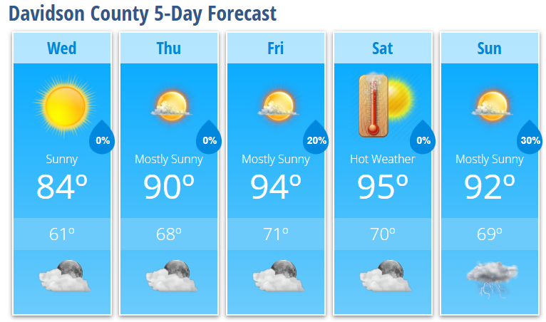
Today's Forecast
Sunny skies and lower humidity will make for a pleasant Wednesday across Davidson County. High temperatures will reach around 84 degrees this afternoon with light winds.
Tonight will remain mostly clear and comfortable with lows dipping to around 61 degrees.
Warming Trend Begins Thursday
The cooler air mass currently in place will quickly give way to warmer conditions as high pressure shifts offshore and southerly winds return.
Thursday will feature mostly sunny skies and a high near 90 degrees.
By Friday, temperatures climb into the mid-90s with highs reaching around 94 degrees under mostly sunny skies. Humidity levels will also begin increasing, making it feel even warmer during the afternoon.
Weekend Heat Continues
Saturday remains hot with mostly sunny skies and highs near 95 degrees.
While temperatures this weekend may not be quite as extreme as earlier forecasts suggested, it will still be one of the hottest stretches of weather we've experienced so far this summer. Heat index values could approach or exceed 100 degrees during the afternoon hours.
Looking beyond the weekend, temperatures may ease slightly Monday and Tuesday thanks to an onshore flow pattern, but forecast guidance continues to indicate potentially dangerous heat could develop by the middle to latter part of next week.
Better Storm Chances Sunday
Most of Friday and Saturday remain dry, although an isolated thunderstorm cannot be completely ruled out Friday night.
The better opportunity for showers and thunderstorms arrives Sunday as a backdoor cold front approaches the region.
Sunday will be mostly sunny with a high near 92 degrees before scattered afternoon and evening thunderstorms develop. Current rain chances are around 30 percent, with the strongest storms capable of producing gusty winds.
Looking Ahead
The overall pattern suggests storm chances will peak Sunday before drier conditions return early next week. Meanwhile, I'll continue watching temperature trends closely as forecast models hint at the potential for more significant heat developing later next week.
Davidson County Forecast
Wednesday: Sunny, high 84.
Wednesday Night: Mostly clear, low 61.
Thursday: Mostly sunny, high 90.
Thursday Night: Mostly clear, low 68.
Friday: Mostly sunny, high 94.
Friday Night: Slight chance of showers and thunderstorms, low 71.
Saturday: Mostly sunny, high 95.
Saturday Night: Partly cloudy, low 70.
Sunday: 30% chance of afternoon thunderstorms, high 92.
Sunday Night: 30% chance of evening thunderstorms, low 69.
The bottom line: Enjoy today's comfortable conditions because a summer warm-up is underway. Highs surge into the 90s by the end of the week, with heat index values approaching 100 degrees this weekend before storm chances increase Sunday.