ROWAN COUNTY FORECAST
Tuesday, June 23, 2026
Good morning Rowan County!
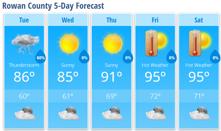
A cold front will move through the area today, bringing the best chance for showers and thunderstorms late this morning through the early afternoon hours. Some storms could become strong, with damaging straight-line winds being the primary concern. While the highest severe weather threat remains east of the Triad, Rowan County remains in the Marginal Risk area and I'll be watching any storms that can maintain their strength as they move out of the mountains.
TODAY
Showers and thunderstorms likely, mainly before 2 PM
A few storms could produce damaging wind gusts
Becoming partly sunny later in the day
High: 86°
Southwest wind 6-9 mph becoming northwest this afternoon
TONIGHT
Mostly clear and noticeably cooler
Low: 60°
WEDNESDAY
Sunny and comfortable
High: 85°
Low humidity
THURSDAY
Sunny and warmer
High: 91°
FRIDAY
Mostly sunny and hot
High: 95°
SATURDAY
Mostly sunny and hot
High: 95°
WHAT I'M WATCHING
Today's thunderstorms will arrive from west to east between late morning and early afternoon. The strongest storms could produce wind gusts capable of bringing down small limbs and causing isolated power outages.
Behind today's cold front, Wednesday will be one of the nicest days we've seen in quite some time with lower humidity and highs in the mid-80s.
The heat quickly rebuilds late week. High temperatures climb back into the mid-90s Friday and Saturday, with even hotter conditions expected Sunday and Monday. Heat index values could approach 100-105 degrees by the end of the weekend.
Bottom Line:
Keep an eye on the sky through early afternoon today, especially if you have outdoor plans. After that, enjoy a beautiful Wednesday because the summer heat machine turns right back on for the weekend.