DAVIE COUNTY FORECAST
Tuesday, June 23, 2026
Good morning Davie County!
A cold front will move through the area this morning, bringing scattered showers and a few thunderstorms before conditions improve this afternoon. While the severe weather threat has diminished compared to earlier expectations, a few storms could still produce brief heavy rain and gusty winds before moving east.
TODAY
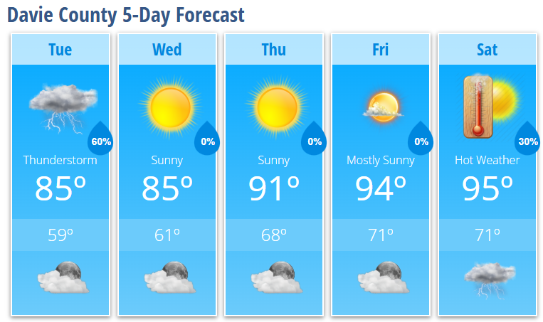
Showers and thunderstorms likely, mainly before 1 PM
Becoming sunny during the afternoon
High: 85°
Southwest wind 5-10 mph becoming northwest
Wind gusts up to 20 mph
TONIGHT
Mostly clear and comfortable
Low: 59°
WEDNESDAY
Sunny and pleasant
High: 85°
Lower humidity
WEDNESDAY NIGHT
Partly cloudy
Low: 61°
THURSDAY
Sunny and dry
High: 91°
FRIDAY
Mostly sunny and hot
High: 94°
SATURDAY
Mostly sunny and hot
High: 95°
30% chance of afternoon thunderstorms
WHAT I'M WATCHING
Most of today's rainfall will occur this morning through early afternoon as a cold front slides across the region. Any additional afternoon storm development should remain isolated.
Wednesday and Thursday look excellent with lower humidity, sunshine, and comfortable mornings. Thursday is now trending drier than previous forecasts.
Summer heat returns in a big way by the weekend. High temperatures will climb into the mid-90s Friday and Saturday, with heat index values likely exceeding 100 degrees at times.
Bottom Line:
Keep the umbrella handy this morning, but better weather is on the way. Enjoy the midweek break from the heat because another stretch of hot summer weather arrives just in time for the weekend.