Rowan County Weather Forecast
Storm Chances Continue Tuesday Before a Pleasant Midweek Break
Good Monday evening everyone!
The cold front responsible for today's showers and thunderstorms will still be influencing our weather on Tuesday before drier air arrives for the middle of the week.
While Tuesday won't be a washout, additional showers and thunderstorms remain possible before much nicer weather arrives Wednesday.
Tuesday: A Few Storms Remain Possible
Tuesday begins with the potential for lingering showers and thunderstorms, especially during the morning and early afternoon as the cold front slowly moves east of the area.
Skies will become partly sunny at times with temperatures reaching around 87 degrees during the afternoon.
Rain chances remain elevated through much of the day with a 60% chance of showers and thunderstorms, mainly before 4 PM.
Any storms that develop could produce locally heavy rainfall and lightning, but the overall severe weather threat should be much lower than what we experienced Monday evening.
Winds will become west-northwest at 5 to 9 mph during the day as slightly drier air begins filtering into the region.
Tuesday Night: Clearing and Cooler
By Tuesday evening, showers and thunderstorms should come to an end as the front finally exits the area.
Skies will become mostly clear overnight with temperatures falling to around 62 degrees.
A refreshing north wind will make it feel noticeably more comfortable compared to recent nights.
Wednesday: The Pick of the Week
Wednesday looks fantastic.
Sunny skies
High near 86°
Lower humidity
Overnight low near 65°
High pressure building into the Carolinas will provide a brief break from the heat and humidity.
If you've been waiting for a comfortable summer day to spend outside, Wednesday is probably your best opportunity this week.
Looking Ahead
The break won't last long.
By Thursday, moisture begins returning to the region and isolated afternoon thunderstorms become possible once again.
Thursday:
Mostly sunny
High near 90°
Friday:
30% chance of afternoon thunderstorms
High near 93°
Saturday:
Mostly sunny and hot
High near 95°
Temperatures continue climbing into the weekend, and some locations could once again see heat index values exceed 100 degrees by Sunday.
My Take
After today's active weather, Tuesday serves as a transition day.
The best chance for additional showers and storms will be during the first half of the day before drier air gradually moves in.
Wednesday remains the standout day of the forecast period with sunshine, lower humidity, and seasonably warm temperatures.
Unfortunately, the heat begins building again late this week, and by the weekend we'll be talking about highs back in the middle 90s.
Rowan County Forecast
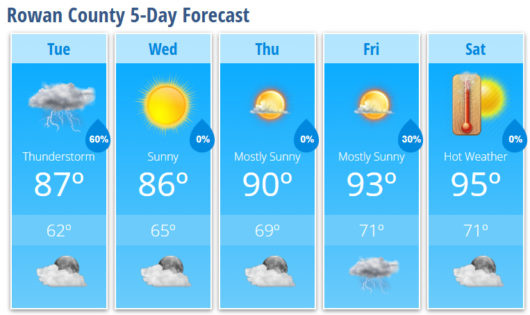
Tuesday: Showers and thunderstorms likely, mainly before 4 PM, high 87°
Tuesday Night: Mostly clear, low 62°
Wednesday: Sunny, high 86°
Wednesday Night: Mostly clear, low 65°
Thursday: Mostly sunny, high 90°
Thursday Night: Mostly clear, low 69°
Friday: 30% chance of afternoon thunderstorms, high 93°
Friday Night: 30% chance of storms before 8 PM, low 71°
Saturday: Mostly sunny and hot, high 95°
Saturday Night: Partly cloudy, low 71°