Davie County Weather Forecast: Strong Storms Possible Today, Cooler and Less Humid Midweek
Good Monday morning, Davie County.
Today will bring our best chance of showers and thunderstorms this week as a cold front approaches from the west. Some of those storms could become strong to severe, with damaging wind gusts being the primary concern.
What Has Changed
Temperatures continue to trend warmer for next weekend and early next week as summer heat begins building back into the region.
Monday: Heat, Humidity and Storms
The morning should remain largely dry, but clouds will increase through the day. By late afternoon and evening, showers and thunderstorms are expected to develop and move across the area ahead of an approaching cold front.
Today's Forecast
-
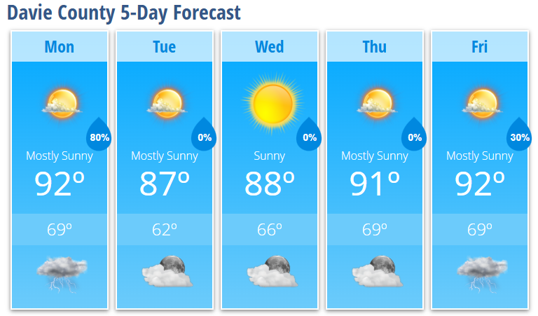
High: 92°
-
Southwest winds 5-9 mph
-
Wind gusts up to 18 mph
-
60% chance of showers and thunderstorms
The greatest threat for storms appears to be between 4 PM and midnight.
Severe Weather Threat
Atmospheric conditions will support the possibility of strong to severe thunderstorms this afternoon and evening.
The primary threats include:
-
Damaging straight-line winds
-
Frequent lightning
-
Heavy rainfall
-
Localized flooding in poor drainage areas
While not everyone will receive rainfall, any stronger storms could produce brief torrential downpours and wind gusts capable of bringing down small limbs and causing isolated power outages.
Confidence remains highest for stronger storms along and north of Interstate 40, which places Davie County in an area I will be watching closely this afternoon and evening.
Tonight
Showers and thunderstorms will continue through much of the evening before gradually ending after midnight.
Tonight's Forecast
-
Low: 69°
-
80% chance of showers and thunderstorms
-
Becoming mostly dry toward daybreak
Tuesday Through Thursday
A cold front moves through overnight, bringing a noticeable drop in humidity for the middle part of the week.
Tuesday
-
Mostly sunny
-
High: 87°
-
Slight chance of an isolated afternoon shower
Tuesday Night
-
Clear
-
Low: 62°
Wednesday
-
Sunny
-
High: 88°
-
Comfortable humidity levels
Thursday
-
Mostly sunny
-
High: 91°
The midweek period will offer some of the most pleasant weather we've experienced recently, with lower humidity and comfortable mornings.
Looking Ahead
Moisture gradually returns late this week.
Friday
-
High: 92°
-
30% chance of afternoon thunderstorms
Shower and thunderstorm chances will continue into the weekend as temperatures climb back into the lower to middle 90s.
Long-range guidance continues to suggest another stretch of significant summer heat developing by late weekend into early next week. Heat index values could once again exceed 100 degrees in portions of the region.
For now, my focus remains on this afternoon and evening's severe weather potential. I'll be monitoring radar trends throughout the day and will provide updates if stronger storms begin developing west of Davie County.