Rowan County Weather Forecast
Hot Start to the Week, Severe Storm Risk Monday Evening
Good Sunday morning everyone!
Summer is officially underway, and Rowan County will see plenty of sunshine and heat over the next couple of days before storm chances return Monday evening.
Today: A Beautiful First Day of Summer
Expect sunny skies throughout the day with temperatures climbing to around 92 degrees this afternoon. Winds will remain light, becoming southwest around 5 mph during the afternoon hours.
Tonight will be mostly clear and warm with lows settling around 69 degrees.
Monday: Heat Builds, Then Storms Move In
Monday will be the hottest day of the forecast period so far, with highs reaching 94 degrees and heat index values approaching 100 degrees during the afternoon.
While much of the day will be dry and mostly sunny, my attention is focused on Monday afternoon and especially Monday evening as a cold front approaches from the northwest.
Confidence continues to increase that strong to severe thunderstorms could develop and move into the area Monday evening. The primary threat will be damaging straight-line winds, although frequent lightning and heavy rainfall will accompany any stronger storms.
The latest forecast guidance suggests the main line of storms may not reach the North Carolina foothills until between 6 PM and 8 PM before progressing eastward through the evening hours. Southwest winds ahead of the front could also gust between 20 and 30 mph during the afternoon.
If you have outdoor plans Monday evening, make sure you have a way to receive weather alerts and be prepared to move indoors quickly if warnings are issued.
Monday night's forecast includes a 60% chance of showers and thunderstorms, mainly before midnight. Temperatures will fall to around 69 degrees overnight.
Tuesday Through Wednesday: Less Humid and More Comfortable
Behind the front, slightly cooler and less humid air arrives.
Tuesday will be mostly sunny with a high near 90 degrees and a northwest breeze.
Tuesday night will be partly cloudy with lows around 64 degrees.
Wednesday looks excellent with mostly sunny skies and highs near 88 degrees. Overnight lows Wednesday night will drop into the mid-60s.
Looking Ahead to Late Week
A more typical summertime pattern returns Thursday with scattered afternoon and evening thunderstorms possible.
Thursday will be mostly sunny with highs near 90 degrees and a 40% chance of thunderstorms after 2 PM.
Storm chances continue Thursday night before gradually diminishing overnight.
My Take
Today looks great for outdoor activities, but Monday is a day you'll want to keep an eye on the weather. The combination of summer heat, increasing humidity, and an approaching cold front will create an environment supportive of strong thunderstorms Monday evening.
I'll be monitoring trends closely and will provide updates if the severe weather threat increases.
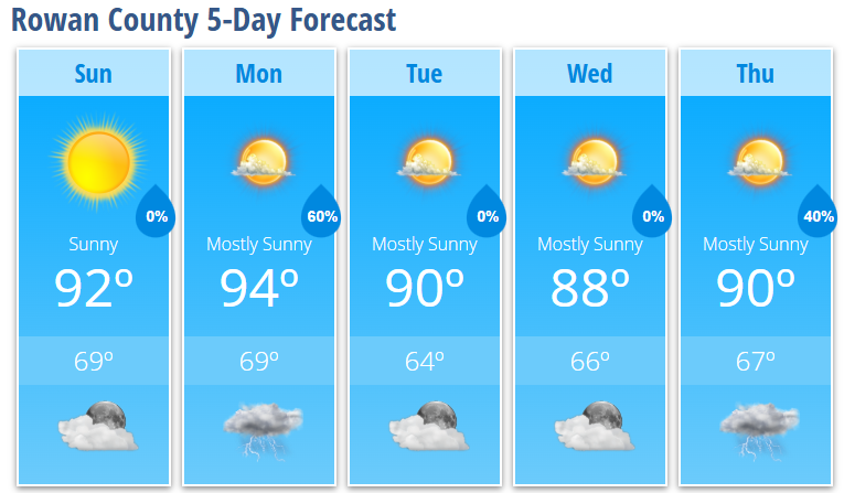
Rowan County Forecast
Sunday: Sunny, high 92°
Sunday Night: Mostly clear, low 69°
Monday: Mostly sunny, high 94°, heat index near 100°
Monday Night: Showers and thunderstorms likely, low 69°
Tuesday: Mostly sunny, high 90°
Tuesday Night: Partly cloudy, low 64°
Wednesday: Mostly sunny, high 88°
Wednesday Night: Mostly clear, low 66°
Thursday: 40% chance of afternoon thunderstorms, high 90°
Thursday Night: 40% chance of thunderstorms, low 67°