Davie County Weather Forecast
Strong Storms Possible Monday Evening Before a Brief Midweek Break
Good Sunday evening, Davie County!
The weather remains quiet tonight, but Monday continues to be the day I'm watching closely as a cold front approaches from the northwest. Strong to severe thunderstorms remain possible Monday afternoon and evening, with damaging winds continuing to be the primary concern.
Monday: Hot, Humid, and Increasingly Unsettled
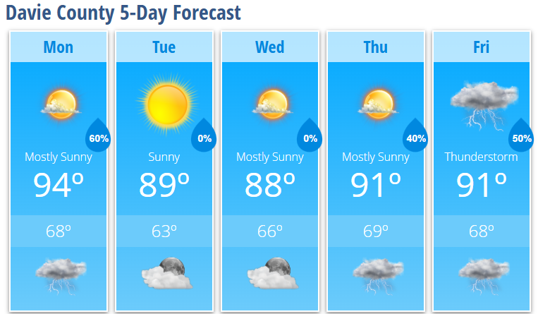
Monday begins with sunshine and temperatures quickly climbing through the 80s before reaching a high near 94 degrees during the afternoon.
Southwest winds will increase to 5 to 10 mph with gusts as high as 21 mph ahead of the approaching front.
A few isolated thunderstorms could develop after 3 PM, but the main concern remains a line of showers and thunderstorms expected to develop ahead of the cold front and move east through the region during the late afternoon and evening hours.
Severe Weather Threat
The atmosphere is expected to become increasingly unstable Monday afternoon, creating an environment capable of supporting strong to severe thunderstorms.
The primary threat remains:
Damaging wind gusts
Additional concerns include:
Frequent lightning
Brief heavy rainfall
Downed tree limbs
Isolated power outages
The latest forecast guidance suggests the main severe weather window will be approximately 4 PM through Midnight, although some storms could develop earlier during the afternoon.
While confidence remains highest closer to the mountains and along and north of Interstate 40, Davie County remains within an area where a few stronger storms could occur.
Monday Night
Showers and thunderstorms remain likely through the evening before gradually ending overnight.
Skies will slowly clear after midnight with temperatures falling to around 68 degrees.
Tuesday: Drier With Morning Fog Possible
Tuesday morning could begin with widespread dense fog, especially in locations that receive rainfall Monday evening.
After the fog lifts, expect plenty of sunshine with highs near 89 degrees.
Northwest winds will develop during the day as slightly drier air filters into the area.
Tuesday night will be partly cloudy with lows around 63 degrees.
Midweek Outlook
Wednesday looks excellent with mostly sunny skies and highs around 88 degrees.
Wednesday night remains partly cloudy with lows near 66 degrees.
Late Week Pattern
A more typical summertime pattern returns during the second half of the week.
Thursday brings a 40% chance of afternoon thunderstorms with highs reaching 91 degrees.
Storm chances continue Thursday night and again Friday as scattered showers and thunderstorms remain possible.
My Take
Monday remains the day to watch.
Confidence continues to increase that thunderstorms will develop somewhere across the western Carolinas and move east through the evening hours. The biggest question remains how much strength those storms maintain as they move into the Piedmont.
While widespread severe weather is not expected, some storms could produce damaging wind gusts.
If you have outdoor plans Monday afternoon or evening, make sure you have multiple ways to receive weather warnings and be prepared to head indoors quickly if storms approach.
Davie County Forecast
Monday: 40% chance of thunderstorms after 3 PM, high 94°
Monday Night: Showers and thunderstorms likely, low 68°
Tuesday: Sunny after morning fog, high 89°
Tuesday Night: Partly cloudy, low 63°
Wednesday: Mostly sunny, high 88°
Wednesday Night: Partly cloudy, low 66°
Thursday: 40% chance of afternoon thunderstorms, high 91°
Thursday Night: 40% chance of thunderstorms, low 69°
Friday: 50% chance of showers and thunderstorms, high 91°
Friday Night: 30% chance of thunderstorms, low 68°