Davidson County Weather Forecast
Summer Heat Builds Monday, Strong Storms Possible by Evening
Good Sunday morning, Davidson County!
The first weekend of summer is bringing plenty of sunshine and warm temperatures, but my attention is turning toward Monday afternoon and evening when strong thunderstorms could develop as a cold front approaches from the northwest.
Today: Sunny and Pleasant
Expect abundant sunshine today with temperatures climbing to around 91 degrees this afternoon. Winds will remain light before becoming southerly around 6 mph during the afternoon.
Tonight will be partly cloudy and warm with lows around 69 degrees.
Monday: Hot, Humid, and Stormy Late
Monday will be the hottest day of the forecast period with temperatures reaching 94 degrees and heat index values approaching 100 degrees during the afternoon.
A warm and increasingly humid southwest flow will set the stage for thunderstorm development later in the day as a cold front approaches the region.
The Storm Prediction Center has expanded a Slight Risk (Level 2 of 5) for severe weather across portions of the western Piedmont, including much of Davidson County. Current forecast guidance suggests storms developing over the mountains and foothills could organize and move east during the late afternoon and evening hours.
The primary threat will be damaging straight-line winds, although frequent lightning and heavy downpours will accompany stronger storms.
A few isolated storms could develop ahead of the main line during the afternoon, but the greatest concern remains from late afternoon through the evening hours.
If you have outdoor plans Monday evening, make sure you have a reliable way to receive weather alerts and be prepared to move indoors quickly if warnings are issued.
Monday night brings a 60% chance of showers and thunderstorms with activity continuing into the overnight hours. Temperatures will fall to around 69 degrees.
Tuesday and Wednesday
The cold front will push east of the area Tuesday, but a slight chance of an afternoon thunderstorm remains possible.
Tuesday will be mostly sunny with a high near 89 degrees.
Tuesday night will be mostly clear with lows around 64 degrees.
Wednesday looks excellent with mostly sunny skies and highs near 88 degrees. Wednesday night will remain mostly clear with lows around 66 degrees.
Looking Ahead
The remainder of the week features a more typical summertime weather pattern.
Thursday will bring a 40% chance of afternoon and evening thunderstorms with highs near 90 degrees.
Storm chances continue Thursday night before gradually diminishing overnight.
My Take
Today is a great day to enjoy being outdoors, but Monday is clearly the day to watch.
Heat index values near 100 degrees will make it feel quite uncomfortable during the afternoon, and the atmosphere will become increasingly favorable for strong thunderstorms by evening. Damaging wind gusts remain the primary concern, and I'll continue monitoring trends closely over the next 24 hours.
Davidson County Forecast
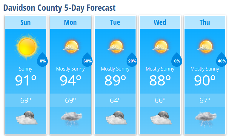
Sunday: Sunny, high 91°
Sunday Night: Partly cloudy, low 69°
Monday: 30% chance of thunderstorms late, high 94°
Monday Night: Showers and thunderstorms likely, low 69°
Tuesday: Slight chance of afternoon thunderstorms, high 89°
Tuesday Night: Mostly clear, low 64°
Wednesday: Mostly sunny, high 88°
Wednesday Night: Mostly clear, low 66°
Thursday: 40% chance of afternoon thunderstorms, high 90°
Thursday Night: 30% chance of thunderstorms, low 67°