Tropical Storm Arthur Forms in the Gulf: What It Means for Rowan, Davie, and Davidson Counties
As expected, the system I have been tracking over the western Gulf of Mexico has officially strengthened into Tropical Storm Arthur.
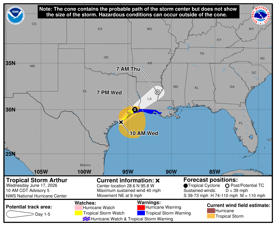
The National Hurricane Center upgraded the system Wednesday morning after Hurricane Hunter aircraft found tropical-storm-force winds and increasing thunderstorm organization east of the center. Arthur currently has maximum sustained winds of 40 mph and is moving northeast along the Texas coast.
The good news for North Carolina is that Arthur itself is not expected to move into our area as a tropical storm. In fact, the center will move inland across southeastern Texas and southwestern Louisiana before weakening and dissipating.
However, that does not mean we will escape impacts entirely.
Why Rowan, Davie, and Davidson Counties Still Need to Pay Attention
Even though Arthur will weaken well before reaching the Carolinas, its moisture will become entrained into a larger weather system crossing the eastern United States.
That moisture will help fuel increasing shower and thunderstorm chances Thursday afternoon through Friday across the western Piedmont.
The biggest impacts for our area remain:
Gusty Winds Thursday
Confidence remains high that Thursday will be a windy day across Rowan, Davie, and Davidson Counties.
Southwest winds will increase to 15 to 20 mph at times, with wind gusts frequently reaching 25 to 35 mph during the afternoon and evening.
These winds are not being caused directly by Arthur but rather by the overall weather pattern surrounding the tropical system and an approaching upper-level trough.
Residents should secure lightweight outdoor items, including umbrellas, trash cans, lawn decorations, and patio furniture.
Rain Returns Thursday Night Into Friday
Rain chances will begin increasing Thursday afternoon before becoming more widespread Thursday night into Friday.
The latest forecast trends continue to place the heaviest rainfall well south of North Carolina, stretching from Louisiana through portions of Mississippi, Alabama, Georgia, and the Florida Panhandle where flash flooding remains a major concern.
For Rowan, Davie, and Davidson Counties, this appears to be more of a beneficial rainfall event rather than a flooding event.
Current expectations are for rainfall amounts generally between one-quarter and three-quarters of an inch, although isolated higher totals are possible where thunderstorms develop.
While every drop is welcome given the ongoing drought conditions, this does not currently appear to be the drought-busting rainfall event many have been hoping for.
Isolated Strong Storms Remain Possible
One aspect I'll continue monitoring closely is the possibility of isolated strong to severe thunderstorms Thursday afternoon and evening.
As tropical moisture combines with daytime heating and increasing wind energy in the atmosphere, a few storms could produce damaging wind gusts.
At this time, the severe weather threat appears limited, and any stronger storms would likely be isolated rather than widespread.
The primary concern would be straight-line winds capable of downing small tree limbs or causing scattered power outages.
The Weekend Looks Much Better
Once the remnants of Arthur and a cold front move east of the region Friday, much drier air will arrive.
Saturday and Sunday are shaping up to be beautiful summer days with plenty of sunshine, lower humidity, and temperatures in the upper 80s to lower 90s.
My Bottom Line
The formation of Tropical Storm Arthur does not change my local forecast significantly.
For Rowan, Davie, and Davidson Counties:
Windy conditions Thursday with gusts up to 35 mph
Increasing rain chances Thursday night and Friday
A few stronger thunderstorms possible
Some beneficial rainfall expected
No direct tropical storm impacts expected
No widespread flooding expected at this time
No major drought relief expected
I'll continue monitoring forecast trends throughout the day and will provide updates if rainfall totals or severe weather concerns increase.
For now, enjoy today's sunshine because our next round of active weather arrives late Thursday.