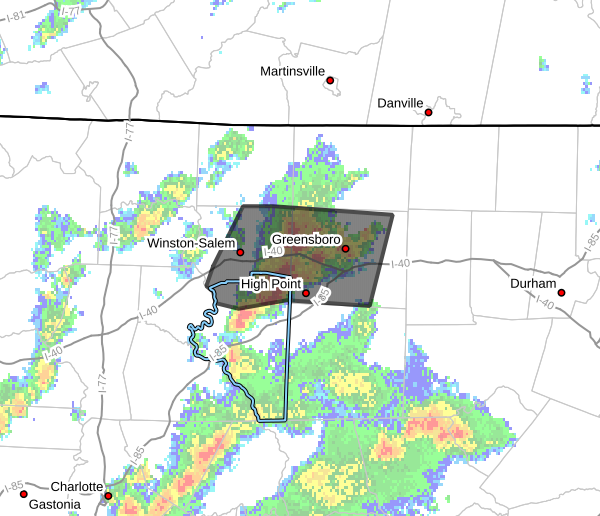
Flood Advisory Issued For Parts Of The Triad Through 5:30 PM
Heavy rainfall and thunderstorms continue across portions of central North Carolina this afternoon, prompting the National Weather Service to issue a Flood Advisory until 5:30 PM EDT for parts of the Triad region.
The advisory includes portions of Davidson, Forsyth, and Guilford counties.
According to Doppler radar estimates around 3:28 PM, between 1 and 2 inches of rain had already fallen across parts of the advisory area, with an additional 0.5 to 1.5 inches possible through the remainder of the afternoon.
Minor flooding is expected in low-lying areas, along streets, and in locations with poor drainage.
Communities included in the advisory include:
- Winston-Salem
- High Point
- Kernersville
- Clemmons
- Greensboro
- Jamestown
- Walkertown
- Summerfield
- Stokesdale
- McLeansville
- Pleasant Garden
- Colfax
- Belews Creek
- Areas around Lake Brandt, Lake Townsend, and Belews Lake
Thunderstorms have been producing slow-moving heavy downpours this afternoon, which has increased the risk for localized flooding issues where storms repeatedly move over the same areas.
While Rowan County is not currently included in the advisory, additional showers and thunderstorms remain possible across the region through this evening.
Drivers are urged to use caution during periods of heavy rain. Remember:
Turn Around, Don’t Drown.
Most flood-related deaths occur in vehicles when drivers attempt to cross flooded roadways.
Rowan County Weather will continue monitoring radar trends and provide updates if additional advisories or warnings are issued later this evening.