
Strong Thunderstorm Moving Northeast Near Lexington at 45 MPH
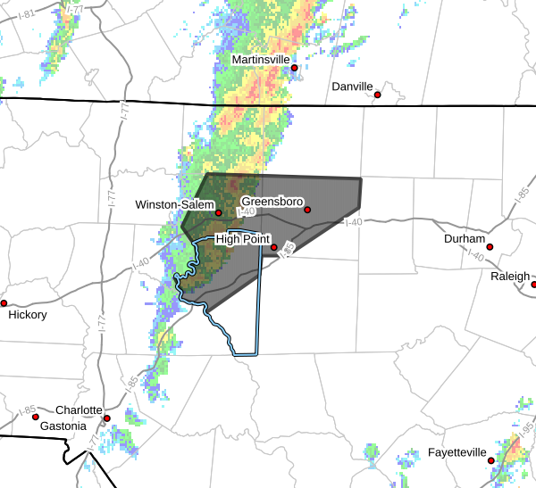
A strong thunderstorm was being tracked by Doppler radar at 8:04 AM EDT, moving northeast across the Triad region.
The storm was located about 7 miles southeast of Bermuda Run or roughly 8 miles northwest of Lexington and moving northeast at 45 mph.
Hazards With This Storm
Forecasters say the storm may produce:
-
Wind gusts up to 40 mph
-
Pea-sized hail
Potential Impacts
Gusty winds could:
-
Knock down small tree limbs
-
Blow around unsecured outdoor objects
Minor hail damage to vegetation is also possible in the stronger portions of the storm.
Communities Impacted
This storm is currently impacting parts of the Triad region, including:
-
Greensboro
-
Winston-Salem
-
High Point
-
Kernersville
-
Clemmons
-
Bermuda Run
-
Walkertown
-
Stokesdale
-
Summerfield
Nearby Highways
The storm is also affecting areas near:
-
Interstate 40 near Mile Marker 132
-
Interstate 40 between Mile Markers 182 and 226
What This Means for Rowan County
At this time, the storm is north of Rowan County, but storms across the region continue moving quickly to the northeast this morning.
Rowan County Weather will continue monitoring radar and will post updates if strong storms move closer to the area.
Safety Reminder
If you are outdoors and storms approach your location, seek shelter inside a sturdy building until the storm passes.
Rowan County Weather will continue providing updates as storms move across the region this morning.