
Severe Thunderstorm Warning Issued for Southern Rowan County Until 10:45 AM
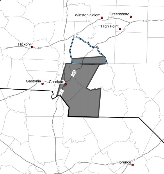
The National Weather Service in Greenville-Spartanburg has issued a Severe Thunderstorm Warning that includes southern Rowan County.
The warning is in effect until 10:45 AM EDT.
The warning also includes Cabarrus, Mecklenburg, and Union counties.
Storm Location and Movement
At 9:37 AM, Doppler radar indicated a line of severe thunderstorms extending from northeast of Huntersville to east of Rock Hill, moving east at 40 mph.
This line of storms will continue pushing across the Charlotte metro area and into surrounding communities through the late morning hours.
Main Hazard
The primary threat with these storms is:
-
Wind gusts up to 60 mph
Potential Impacts
Strong winds could:
-
Knock down trees and tree limbs
-
Damage power lines
-
Cause scattered power outages
Residents should be prepared for rapidly changing conditions as the storms move through.
Communities Impacted
Communities in the warning area include:
-
Charlotte
-
Huntersville
-
Kannapolis
-
Downtown Concord
-
Monroe
Portions of southern Rowan County, including areas near Kannapolis, could experience strong winds as the line moves east.
Safety Reminder
If severe storms approach your location:
-
Move to an interior room on the lowest floor of a sturdy building
-
Stay away from windows
-
Remain sheltered until the storm passes
Report Storm Damage
The National Weather Service encourages residents to report damaging winds, hail, or flooding.
Reports can be made by calling 1-800-267-8101 or by posting on social media using #nwsgsp with the location and description of the event.
Rowan County Weather Will Continue Monitoring
Rowan County Weather will continue monitoring radar and National Weather Service updates and will provide additional updates if warnings are extended or new storms develop across the region.