Enhanced Risk for Severe Weather Monday Across Rowan, Davie, and Davidson Counties
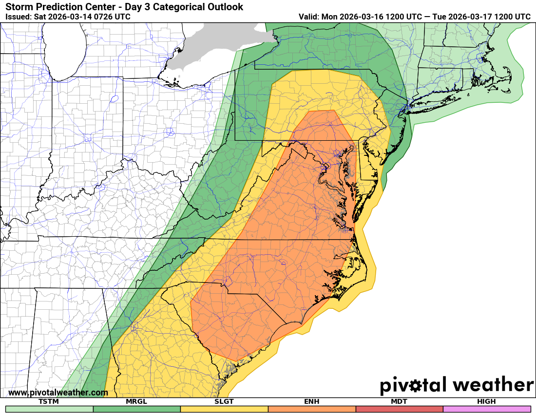
Residents across Rowan County, Davie County, and Davidson County should prepare for the potential of severe thunderstorms on Monday. The Storm Prediction Center has placed much of the Carolinas under an Enhanced Risk (Level 3 of 5) for severe weather.
This level indicates that numerous severe storms are possible, including widespread damaging winds and tornadoes.
What the Enhanced Risk Means
An Enhanced Risk is issued when meteorologists expect organized severe thunderstorms capable of producing multiple reports of severe weather.
For Monday, the primary threats across the region include:
-
Damaging wind gusts that could exceed 60 mph
-
Several tornadoes, some possibly strong
-
Heavy rainfall and frequent lightning
-
Fast-moving storm lines capable of producing widespread impacts
The risk area stretches from the Carolinas northward through Virginia and into parts of the Mid-Atlantic.
Why This System Is Concerning
Meteorologists are tracking a large and strengthening upper-level storm system that will move from the Mississippi and Tennessee Valleys into the Appalachian region on Monday.
Ahead of this system:
-
Warm, humid air will surge northward into the Carolinas
-
Dew points are expected to climb into the 60s, providing fuel for thunderstorms
-
Very strong winds in the atmosphere will help storms organize and intensify
Storms are expected to be ongoing along the cold front Monday morning, but the greatest severe threat will likely develop during the afternoon and early evening hours as the front approaches and daytime heating increases instability.
Forecasters note that supercells may develop ahead of the main squall line, increasing the risk for tornadoes.
Damaging Winds and Tornado Potential
The overall setup supports a significant severe weather event across parts of the Southeast and Mid-Atlantic.
Strong wind energy in the atmosphere combined with available instability could allow storms to produce:
-
Widespread damaging wind gusts
-
Embedded tornadoes within a squall line
-
Discrete supercells capable of producing tornadoes
Some forecast models show very favorable conditions for rotating storms, including strong low-level wind shear that can support tornadic thunderstorms.
While details such as exact timing and storm intensity may still change, forecasters say damaging winds appear likely across a large area, with at least a few tornadoes possible.
Timing for the Local Area
For Rowan, Davie, and Davidson counties, the most likely timeframe for severe weather currently appears to be:
Monday afternoon through early evening
However, storms could develop earlier in the day, and additional storms may occur along the advancing cold front.
Residents should monitor updated forecasts as the system approaches.
How to Prepare Now
With the potential for severe weather, now is the time to review your safety plans.
Make sure you:
-
Have multiple ways to receive weather warnings
-
Know where you will go if a Tornado Warning is issued
-
Identify a safe shelter location such as an interior room on the lowest floor of a sturdy building
-
Avoid relying solely on outdoor sirens or a single alert method
Mobile homes and manufactured homes are especially vulnerable during severe storms and tornadoes, so residents should plan ahead for safer shelter options.
Stay Weather Aware
Forecast details will continue to be refined over the next 24 hours as new data becomes available. Rowan County Weather will continue to provide updates as the situation develops.
Check back frequently for the latest forecast updates and safety information.
For ongoing coverage and alerts, visit:
RowanCountyWeather.com