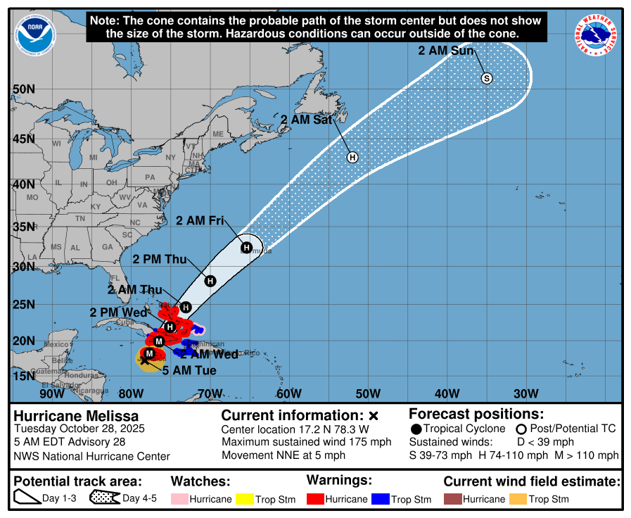
Hurricane Melissa Update
Hurricane Melissa has developed a circular eye approximately 10 nautical miles wide, surrounded by a highly symmetric ring of intense convection with cloud tops colder than -80 °C. Recent radar data from Jamaica indicate a possible secondary outer eyewall, which may signal the onset of an eyewall replacement cycle. Dropsonde data and Air Force Hurricane Hunter observations show 700-mb height falls within the eye and a central pressure near 901 mb. A standard reduction of the peak 700-mb flight-level winds (165 kt) supports an estimated current intensity of about 150 kt.
Melissa is moving slowly north-northeast at about 4 kt (025°). Over the next several days the hurricane is expected to accelerate northeastward as it becomes entrained in the flow ahead of an amplifying trough over the southeastern United States. The forecast track takes Melissa across Jamaica today, eastern Cuba early Wednesday, and the southeastern or central Bahamas later Wednesday. The system then is expected to pass near Bermuda Thursday night or early Friday. The official track closely matches the previous forecast, with a slight adjustment to the left in the 72-120 h window based on new multi-model consensus and Google DeepMind ensemble guidance.
Intensity fluctuations are likely today due to internal processes such as an eyewall replacement cycle. Regardless, Melissa is forecast to reach Jamaica as an extremely dangerous major hurricane within the next 12 hours. Land interaction over Jamaica and eastern Cuba will likely induce some weakening, but the system is still expected to reach the Bahamas as a strong hurricane on Wednesday. Later in the week, increasing westerly shear and higher latitude transition are forecast to broaden the wind field and introduce asymmetry, especially as the system approaches Bermuda. Minor upward adjustments to the intensity forecast have been made for the mid-period, with Melissa expected to transition to a strong extratropical cyclone over the North Atlantic by 96 h.
Key Messages:
-
Jamaica: Catastrophic flash flooding, landslides and destructive winds will continue today with widespread infrastructure damage, power and communication outages, and isolated communities. Life-threatening storm surge and large waves are expected along the southern coast.
-
Haiti & Dominican Republic: Catastrophic flash flooding and landslides are expected across southwestern Haiti and southern Dominican Republic through mid-week. Major damage and community isolation are likely.
-
Eastern Cuba: Heavy rainfall, flash flooding and landslides are expected soon. Life-threatening storm surge and destructive winds are likely to begin later today. Complete preparations now.
-
Southeastern & Central Bahamas and Turks & Caicos: Hurricane conditions, life-threatening storm surge and heavy rainfall are expected Wednesday. Finish preparations by tonight and closely follow local official guidance.