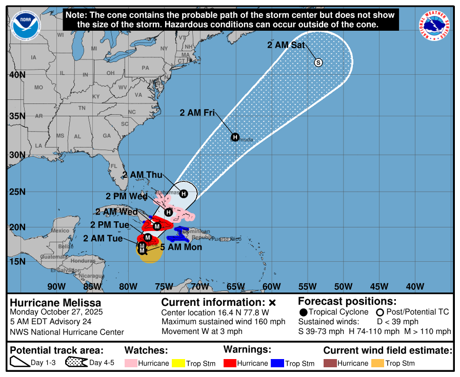
Hurricane Melissa Reaches Category 5 Strength as Jamaica Braces for Catastrophic Impacts
The National Hurricane Center reports that Hurricane Melissa has intensified into a Category 5 storm as it moves slowly toward Jamaica. An Air Force Reserve Hurricane Hunter aircraft measured peak winds of 154 knots (about 140 knots at the surface) and a central pressure of 917 mb, confirming Melissa’s status as one of the strongest Atlantic hurricanes of the year.
The storm’s eye is roughly 10 nautical miles wide with temperatures near 20°C, surrounded by towering thunderstorms reaching as cold as -86°C at their tops — a sign of extreme intensity.
Melissa is currently moving west at just 3 knots, but forecasters expect a slow turn toward the northwest and north during the next 24 hours. The latest track calls for landfall on Jamaica’s south coast early Tuesday morning, crossing the island before emerging off the north coast by Tuesday afternoon. From there, Melissa is forecast to pass across southeastern Cuba and the southeastern Bahamas Tuesday night and Wednesday, reaching near Bermuda by Thursday night.
The National Hurricane Center has shifted the western Atlantic portion of the forecast track slightly westward, following updated guidance from the latest Google DeepMind and European model solutions.
Further strengthening remains possible through Monday night as the storm remains south of Jamaica over warm ocean waters and in an area of low wind shear. Eyewall replacement cycles could cause some fluctuations in intensity.
Forecasters emphasize that a Category 4 or Category 5 landfall will produce catastrophic damage regardless of minor intensity differences. Wind speeds in Jamaica’s mountainous regions may exceed those at sea level, compounding damage potential.
Although Melissa is expected to weaken slightly after crossing Jamaica, the system should remain a major hurricane across southeastern Cuba and the southeastern Bahamas, possibly retaining hurricane strength as it nears Bermuda later this week.
Key Impacts by Region
Jamaica:
Catastrophic, life-threatening flash flooding and landslides are likely through Tuesday. Destructive winds will begin this evening, particularly in higher terrain. Expect widespread power and communication outages, structural damage, and dangerous storm surge along the south coast.
Haiti and the Dominican Republic:
Severe flash flooding and landslides are expected through midweek across southwestern Haiti and southern Dominican Republic. Tropical storm conditions are likely Tuesday and Wednesday.
Eastern Cuba:
Heavy rainfall, flash flooding, and landslides will begin today. Hurricane conditions and storm surge are expected Tuesday night. Residents should finalize preparations immediately.
Southeast Bahamas and Turks and Caicos:
Hurricane conditions, life-threatening storm surge, and heavy rainfall are possible Wednesday. Preparations should be completed by Tuesday night.
The full forecast discussion and updates can be found at nhc.noaa.gov