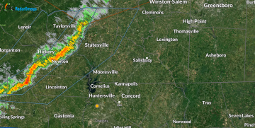
Radar Update — 6:57 PM Sunday
Sunday, October 19, 2025 - 7:00pm
A line of gusty showers continues moving east through the foothills this evening and will approach Rowan County later tonight.
At 6:57 PM EDT, Doppler radar indicated showers and a few thunderstorms along a line from near Taylorsville to Newton and Morganton, moving east at 25 mph.
Hazard: Wind gusts up to 40 mph.
Source: Radar indicated.
Impact: Gusty winds could knock down small limbs and blow around unsecured objects.
Locations currently affected:
Hickory, Newton, Taylorsville, Morganton, Conover, Longview, Sawmills, and Granite Falls.
Rowan County should expect brief gusty winds and light to moderate showers as this line moves east through the evening.