
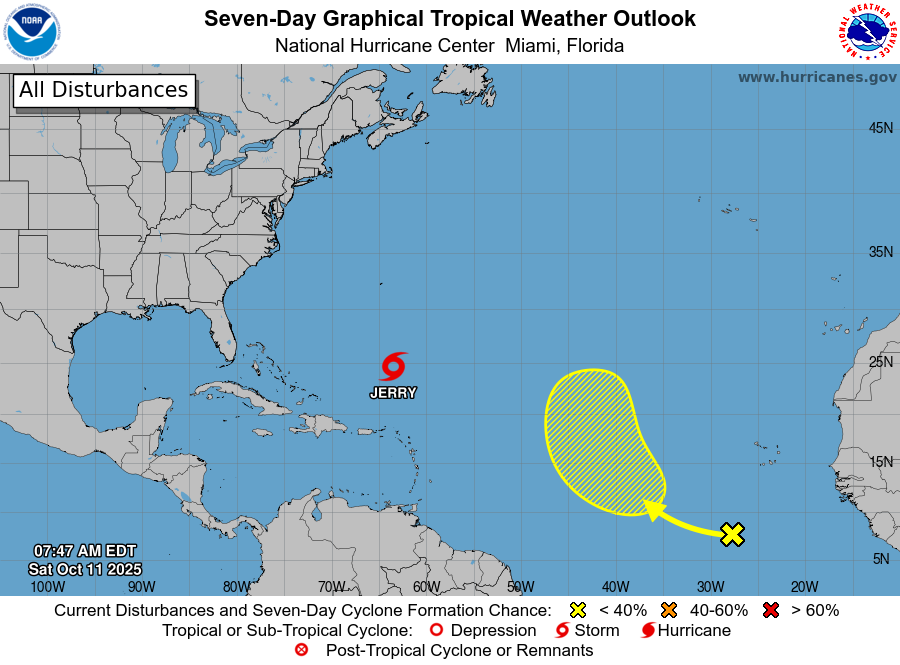
Tropical Storm Jerry — Saturday Morning Update
Maximum Sustained Winds: 50 mph (45 kt)
Movement: North at 14 mph
Location: Over the southwestern Atlantic, roughly midway between the northern Leeward Islands and Bermuda
Current Status
Jerry has become slightly better organized this morning. Satellite and microwave data show new deep convection near the center and hints of curved banding, a sign the system is maintaining some structure.
Winds remain asymmetric, with tropical-storm-force winds mostly confined to the eastern half of the storm.
Forecast Track & Intensity
Jerry is moving northward to north-northeastward along the western edge of a subtropical ridge.
By early next week, it will begin an eastward turn, interacting with a frontal system and eventually merging into the mid-latitude westerlies.
Moderate wind shear and cooler sea-surface temperatures will limit further strengthening. The NHC expects gradual weakening and a transition to an extratropical system within the next few days.
Key Message
Swells generated by Jerry are affecting the Leeward Islands, Windward Islands, Virgin Islands, Puerto Rico, the Dominican Republic, and the Turks and Caicos Islands, with life-threatening surf and rip currents expected.
These swells will spread toward the Bahamas later today.
Elsewhere in the Atlantic
Tropical Wave (Southwest of the Cabo Verde Islands):
A broad area of disorganized showers and thunderstorms continues across the far eastern tropical Atlantic.
Gradual development is possible over the next several days as it moves west-northwest to northwest at 15–20 mph.
-
Formation chance through 48 hours: Low – 10%
-
Formation chance through 7 days: Low – 30%
-
Please let our local sponsors know that you appreciate their support of our blog. Take a moment to visit their website linked at the top of this post.
Share this:

Announcements & Events
Check back often for important announcements and events that I'll be involved in!