Tropical Storm Imelda – 2 PM EDT Update (NHC)
Issued: Sunday, September 28, 2025 • 2:00 PM EDT
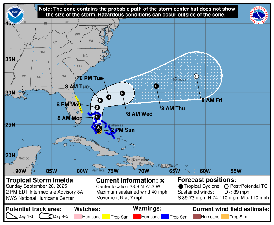
Source: NWS National Hurricane Center – Intermediate Advisory 8A
Overview
The depression has strengthened into Tropical Storm Imelda. While current guidance still shows a turn to the east-northeast away from the Southeast U.S. by midweek, that turn will take time, so near-term impacts continue along the Bahamas and portions of the U.S. East Coast.
Current Position & Intensity
-
Location: 23.9°N, 77.3°W (about 95 miles WNW of the central Bahamas; ~370 miles SE of Cape Canaveral, FL)
-
Movement: North at 7 mph
-
Maximum sustained winds: 40 mph (tropical-storm force)
-
Minimum central pressure: 998 mb
Watches & Warnings
-
Tropical Storm Warning: Central Bahamas (Cat Island, Exumas, Long Island, Rum Cay, San Salvador) and portions of the northwestern Bahamas (Eleuthera, New Providence, Abacos, Berry Islands, Andros, Grand Bahama).
-
Tropical Storm Watch: Florida east coast from the Palm Beach/Martin County Line to the Flagler/Volusia County Line.
Forecast & Track
-
Motion to the north continues today, becoming faster.
-
A turn to the east-northeast is expected Monday–Tuesday, taking the center away from the Southeast U.S. by midweek.
-
Strengthening is likely; Imelda could become a hurricane late Monday or Tuesday.
Hazards
-
Wind: Tropical-storm conditions occurring in the central Bahamas; expected in the northwestern Bahamas later today. Possible along the Florida east coast within the Watch area Monday.
-
Rainfall:
-
Eastern Cuba: Additional 2–6 inches; flash flooding and mudslides possible.
-
Northwestern Bahamas: 6–12 inches through Tuesday; flash/urban flooding likely.
-
Coastal Carolinas: 2–4 inches, locally up to 7 inches through Wednesday morning; flash/urban and isolated minor river flooding possible.
-
-
Storm Surge: 1–3 feet above ground level in onshore flow across the northwestern Bahamas. Minor coastal flooding possible along parts of the Southeastern U.S. coast.
-
Surf/Rip Currents: Swells from Imelda and Hurricane Humberto will bring dangerous surf and rip currents to much of the U.S. East Coast early this week.
Rowan County Outlook
-
Timing: Monday–Tuesday remain our most unsettled period.
-
What to expect: Breezy northeast winds, periods of showers, and pockets of heavier rain.
-
Key point: The forecast shows a sharp turn offshore, but not immediately—local impacts persist until the system accelerates east-northeast.
Residents with coastal plans should follow local beach flags and advisories. Continue to monitor updates for any adjustments to the track or rainfall outlook.