
Tropical Weather Update: Tropical Storm Gabrielle Strengthening in the Atlantic
Issued by the National Hurricane Center – 8:00 AM EDT, Saturday, September 20, 2025
Active Systems
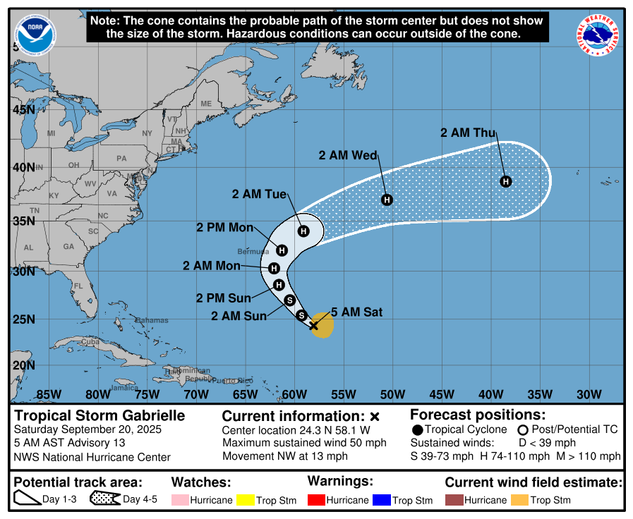
The National Hurricane Center is currently issuing advisories on Tropical Storm Gabrielle, located over the central subtropical Atlantic.
Eastern Tropical Atlantic
A tropical wave over the far eastern Atlantic, southwest of the Cabo Verde Islands, is producing disorganized showers and thunderstorms. Slow development is possible next week as the disturbance tracks west-northwest across the Atlantic.
-
Formation chance through 48 hours: near 0 percent
-
Formation chance through 7 days: 20 percent
Tropical Storm Gabrielle Discussion
As of early Saturday morning, Gabrielle remains a 45-knot (50 mph) tropical storm. Satellite data shows strong convection with very cold cloud tops and lightning, though the storm’s structure remains impacted by moderate wind shear.
-
Current Movement: Northwest at 11 mph
-
Track Forecast: Gabrielle will continue northwest before curving northeast, staying well east of Bermuda Sunday night into Monday. By midweek, guidance suggests Gabrielle transitions into faster mid-latitude flow, with recent model shifts pulling the track farther south than earlier forecasts.
-
Intensity Forecast: With decreasing wind shear expected, Gabrielle is forecast to strengthen, likely becoming a hurricane by Sunday. Peak intensity could approach 90 knots (105 mph) within 2–3 days. Extratropical transition may be delayed due to the adjusted track, and Gabrielle is expected to remain a tropical system through at least 5 days.
Key Messages
-
Gabrielle is forecast to become a hurricane by Sunday and pass east of Bermuda late Sunday into Monday. While the core is expected to remain offshore, wind and rainfall impacts on Bermuda remain possible.
-
Swells from Gabrielle are already reaching Bermuda and will build through the weekend. These swells will cause life-threatening surf and rip currents.
Please let our local sponsors know that you appreciate their support of our blog. Take a moment to visit their website linked at the top of this post.
Share this:

Announcements & Events
Check back often for important announcements and events that I'll be involved in!