
Tropical Depression 7 Forms in the Central Atlantic
Please take a moment to visit our local sponsors to let them know that you appreciate their support of our blog.
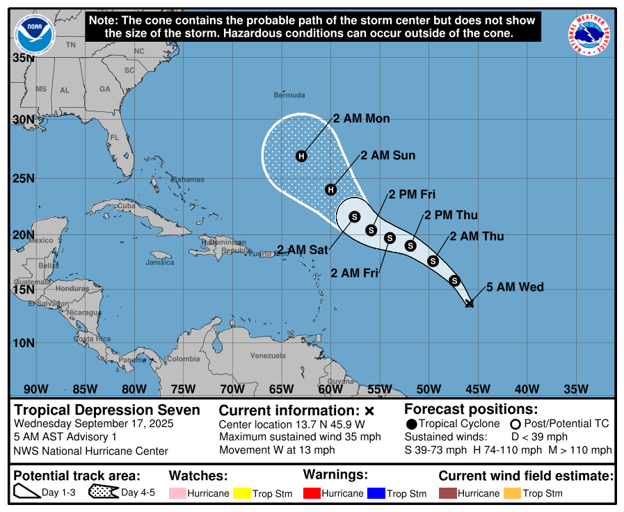
advertise your local business here »The National Hurricane Center reports that Invest 92L has strengthened into Tropical Depression 7 over the central Atlantic.
Current Status:
Satellite and scatterometer data confirm that the system has organized enough to be classified as a tropical cyclone. Maximum sustained winds are near 30 knots (35 mph). While the system is large and somewhat elongated north to south, convection is consolidating around the center.
Location and Movement:
TD 7 is located about midway between the Cabo Verde Islands and the Windward Islands. It is moving west at around 11 knots, though this estimate has low confidence due to the recent formation of the center. A turn to the northwest is expected soon, followed by a west-northwest motion later this week. By the weekend, the depression should begin curving more northwest or north as it approaches the western edge of the Atlantic ridge.
Forecast Track:
There is high confidence that TD 7 will pass well east of the Windward and Leeward Islands. Bermuda should monitor the system closely over the next several days.
Intensity Outlook:
Only modest strengthening is expected in the short term as the depression battles moderate wind shear and pockets of dry air. Conditions should become more favorable by the weekend, allowing for gradual strengthening. The system could reach hurricane strength by early next week, though forecast guidance varies widely from a weak low to a strong hurricane.
Key Point:
TD 7 poses no immediate threat to the Caribbean or the United States. Rowan County Weather will continue to track the system as the Atlantic basin remains active during peak hurricane season.
Please let our local sponsors know that you appreciate their support of our blog. Take a moment to visit their website linked at the top of this post.
Share this:

Announcements & Events
Check back often for important announcements and events that I'll be involved in!