
Severe Weather Threat for Sunday and Monday
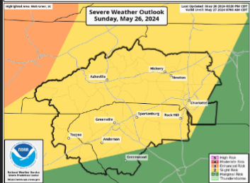
Multiple rounds of showers and thunderstorms will move thru the area this afternoon & evening. A few of these storms could become severe and produce damaging winds and large hail.
TIMING
▪ The First round of showers and thunderstorms is expected to move over the NC mountains and foothills/Piedmont this afternoon thru roughly midnight tonight.
▪ A Second round is a line of thunderstorms approaching the NC mountains around 4 am Monday and then moving thru our forecast area thru the morning hours and possibly into the early afternoon.
▪ A Third round of scattered showers and thunderstorms could develop late Monday afternoon and into the evening across the Western NC mountains and SC Piedmont.
HAZARDS & IMPACTS
▪ Localized damaging wind gusts (58+ mph).
▪ Isolated large hail (1 inch or greater).
▪ Heavy downpours could produce localized flash flooding.
▪ An isolated tornado cannot be ruled out, especially in the NC mountains with the second round of thunderstorms early Monday.
FORECAST CHALLENGES
▪ Whether or not the third round of convection Monday afternoon/evening materializes will be largely dependent on how much of the environment gets worked over with the early morning line of storms. IF the environment can recover, scattered strong to severe thunderstorms could occur.
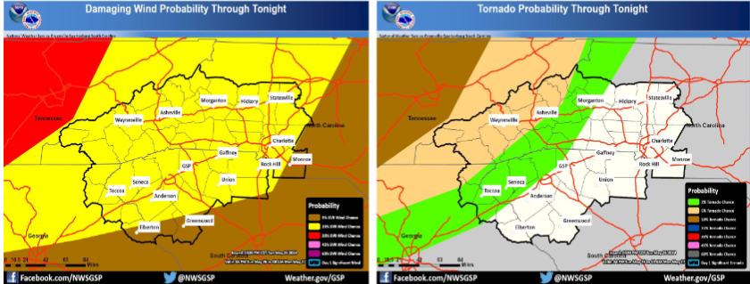
Damaging wind gusts from strong to severe An isolated tornado cannot be ruled out
thunderstorms are the main threat.
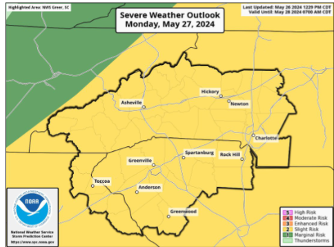
The development of thunderstorms on Monday afternoon/evening will be largely dependent on how much of the environment gets worked over with the early morning line of storms. If the environment can recover, scattered strong to severe thunderstorms could develop.
Please let our local sponsors know that you appreciate their support of our blog. Take a moment to visit their website linked at the top of this post.
Share this:

Announcements & Events
Check back often for important announcements and events that I'll be involved in!