
Florence and the Social Media Machine
There is one thing I have noticed since starting Rowan County Weather. Two types of storm threats create more concern and hype than any other potential storm threat that gets forecasted. The first is the threat of a winter storm. The concern is always when will it start and how much are we going to get? The second type of storm that generates a lot of social media buzz and concern is a hurricane or tropical storm. The first concern is where the storm is going to go? Where will it make landfall? How strong is it going to get? Don't get me wrong these are all great concerns. However, the amount of hype that gets falsely generated on social media creates a lot of anticipation and in many cases causes an even bigger fallout after the threat is over.
There are many social media and websites out there that strive to use these type of storms as a way to generate likes and site traffic. They create fear and cause concern with the use of a single model to instill fear to anyone living in a particular area. One such site created social media posts specific to 3 different states earlier this week concerning Florence. The headlines were the same. The stories were the same. The state names were just replaced in each story.
I know most everyone who follows Rowan County Weather has certainly saw posts on Facebook or Twitter about Florence and where the storm may go. You may have even saw posts about comparisons to Hugo. I now want to take a moment to show you where I stand with Florence and what may happen with the storm. Let me start by saying I am not real fast to post about these types of storms as early as other sites you may see.
- The uncertainty many days out. Models indicating data over 10 days out has an error of around 1,000 miles. Even with the current position of Florence the storm would not have any impact on the east coast until at least late next Thursday or early Friday. That would just be the tropical storm force wind impacts and possible beach erosion from strong surf. There would not be any impact from landfall with the storm. Florence may not make landfall on the east coast for another week and a half.
- The atmospheric conditions the storm will encounter over the next few days. Currently Florence is dealing with a lot of shear which has weakened the storm. Hurricanes that encounter conditions that weaken them tend to take the storm on a more westward path. The storm is expected to enter areas in the Atlantic after passing Bermuda that would be favorable for strengthening. The storm will encounter less shear and be over warmer water. This would allow the storm to gain strength in a considerable amount of time. Models are indicating a high pressure system will set up off the east coast and that could pull the storm to the north. The real question is how far west the storm can make it before that occurs?
- No factual data beyond satellite data. Hurricane Hunters are expected to start flying missions tomorrow to get some data out ahead of Florence. This will allow the models to get information on what the storm will encounter and how the upper level winds may steer the storm over the next 5-7 days. The Hurricane Hunters will go back out on Monday and actually fly into the storm. Once this information is gathered the models will get a much stronger hold on the storm.
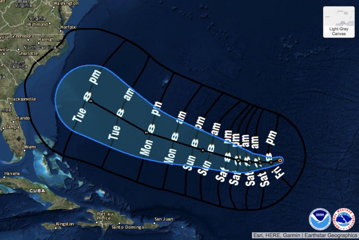
With all that said lets take a look at the current storm track for Florence.
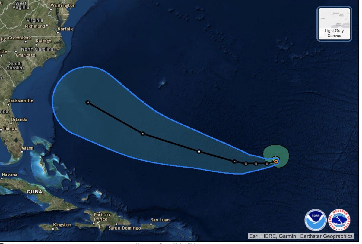
The current track for Florence has the storm west of Bermuda by Tuesday and possibly back to a Category 1 or Category 2 Hurricane. Now you should know the cone you see around the track is about 500 miles wide at its biggest point. So the actual track of the storm could be farther south or even farther north of the potential track that is depicted in the image above. By Tuesday we should certainly have a good idea based on the actual data collected by the Hurricane Hunters on exactly where this storm is going to track and where it is likely to make landfall, if it does on the east coast.
Based on current data from the National Hurricane Center, tropical storm force winds for Florence could be felt along the outer banks by late Tuesday with the storm itself southeast of Charleston. Again, remember there is the potential for error of about 500 miles in the model data from this far out. The storm could be further south or north of the anticipated point. Once the Hurricane Hunters collect their data we will see the error rate become much smaller and the model data will be more dependable.
 T
T
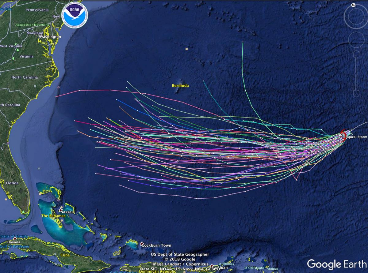
The above image is from the spaghetti plots of all the models. This would include around 50 models and how the data from each of the models are expecting Florence to travel over the next few days. The one consistent thing with the models is that they are all indicating the storm will track west over the next few days. Some of the models are indicating a northward turn near the end of the model run. This would indicate that Florence will begin to encounter high pressure that will steer the storm north and eventually north east. There are several models that keep the storm tracking west with a slight turn to the north. If these hold true you certainly could not rule out North & South Carolina from getting direct impacts form Florence and possible landfall.
Is it time to panic? No. The good news is you still have at least 5-7 days before Tropical Storm Florence winds would impact the outer banks. The thing to do for now is to keep an eye on the information coming in from reliable sources. Those sources would be ones who are telling you there is still some uncertainty. If anyone is telling you the storm will make landfall in a specific area at this point, they are basically trying to drive up page likes and internet traffic to their sites. I will of course provide more updates over the weekend on Florence and the impacts the storm could have on our forecast right here in Rowan County.