
Be Weather Aware on Wednesday
As we begin a few days of very wet weather a Carolina Wedge setup could potentially cause severe weather on Wednesday afternoon. The outlook for potential severe weather for the area is already in place by the Storm Predictions Center. Areas along the i-85 Corridor and east are at a slight risk for severe weather at this point.

The biggest threat will be where the Low pressure system depicted in the model below along with a warm front and occluded front come together and how they interact with each other. This will cause instability in the atmosphere and with that there are several things that we will need to track.

Wind shear will be key as we could see damaging winds.
Then of course there are the CAPE Values or an easy term is Thunderstorm Fuel. In the models as of right now the CAPE is low but for this setup we may not need the CAPE to have severe weather.

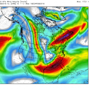
Lastly we will need to keep an eye on the low level jet wind speeds. With the right combination we could see the possibility of rotation in these storms that could trigger a tornado. Now let me be clear. I think as of this time that threat is to our south and east. The key reason I feel that way is the Significant Tornado Parameters for Wednesday afternoon keep the values high out toward the Wilmington area and a small area near Shelby.

However, it is still something I will track and keep an eye on over the model runs as they come in and once these storms start to move through the area. For now just be weather aware for Wednesday and I will keep you posted. Stay dry over the next few days and as always. Thank you for following Rowan County Weather!